2. Current system
In order to design a sustainable public space for Texel, the current system is analysed on the basis of a socio-technical system. Several unsustainabilities and trends resulted from the analysis of the socio-technical system of public space and a conclusion is drawn based on the analysis.
2.1. Socio-technical system
The difference between a socio-technical system and the common sectoral systems is that the fulfilment of societal functions is central in a socio-technical system (ST-system). The sectoral system focuses especially on the development of knowledge and not on the use of technology. The focus of a ST-system is on both innovations and functionality. To achieve change in the current public space, the current dominant system has to change as well. However, this dominant system is always resistant to change. The approach of a ST-system results in a combination of technological niches that together form a new ST-system that replaces the current ST-system by taking advantage of 'windows of opportunity'. (Geels, 2004)
The subsystems of this regime (actors, landscape, technologies, rules & regulations, etc.) are analysed in this section to get to know the current ST-regime and rising trends. Public space is closely related to functionality. In comparison with for example the sub-system 'water' it involves less technologies.
2.1.1.Actors
The first subsystem of the regime that is discussed, are the actors. Users of public space involve inhabitants of Texel and tourists visiting Texel. The public space is owned and maintained by the municipality of Texel.
In the following paragraphs is elaborated on the statistics concerning the users of the public space of Texel. The population of Texel and their tourists are analysed and conclusions are drawn for the implementation of a sustainable public space. The question "Who are actors, their problem definitions, needs, interests etc.?" will be answered in this chapter.
2.1.1.1.Population
Texel has about 13.500 inhabitants. The population of Texel is differing from the population in the Netherlands. The most noticeable fact is the high percentage of inhabitants above 50 years, which is higher for every age group above the 50. This means that there live relatively a lot of elderly people. Another fact that cannot be ignored, are the few people on the island between the 20 and 40 years old. Probably this is related to the opportunities for study and work. The small amount of children between 0 and 10 is probably due to the fact that their parents, the group of people between 20 and 40 years old, are neither living on the island.
The groups that especially should be considered for designing the public space are the elderly people (above 50 years). The group of teenagers should also be taken into account because they are representing the second group of Texel.
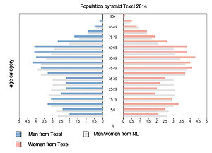
Figure 1: Population of Texelaars (CBS, 2014)
The second graph (Figure 2) shows the variation in population during one year. The natural growth and decline is equal to the growth in municipalities with the same characteristics. However, the migration numbers are clearly higher during spring and lower during fall. This has mainly to do with the fact that people who own a summer cottage move during the high season (summer) to Texel.
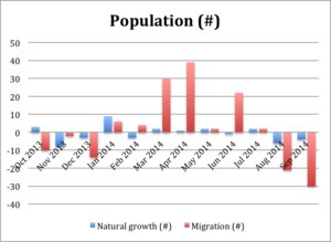
Figure 2: Population Texel (CBS, 2014)
The distribution of the households is slightly different compared to similar municipalities. Texel has a slightly higher percentage of single households. The number of cohabits with children is about 8% smaller and the number of single households slightly higher (Figure 3).
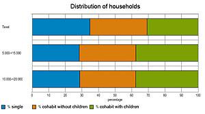
Figure 3: Distribution of households (CBS, 2014)
2.1.1.2.Unemployment
The unemployment rates (unemployed people looking for work) increases during the winter season (Figure 4). During summer these rates are similar to municipalities with same characteristics. There is a clear sine visible in this graph, which could easily related to the economy that is especially based on tourism and agriculture. What is not mentioned in this graph is the amount of hours working during the season. It is likely that during the summer a lot more working hours are made compared to the winter.
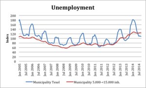
Figure 4: Unemployment of Texelaars (CBS, 2014)
2.1.1.3.Tourism
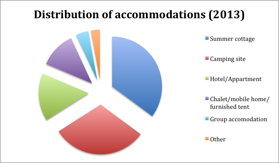
Every year, approximately 800.000 tourists a year visit Texel (Ecomare, 2014). A lot of them spend the night as well for a couple of days. The average number of nights tourists spend on the island is 4,7 nights, which is decreased compared to 2007. About 44.000 places are available where people can spend their nights. The distribution of these accommodations can be found in Figure 5. In ten years, the number of accommodations increased by 7,8%, especially because of the increase in camping sites. Almost 80% of the visitors already visited the island, so the number of returns is high. (VVV Texel, 2014)
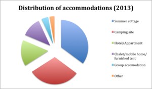
Figure 5: Distribution of accommodations (VVV Texel, 2014)
Figure 6 shows that the largest group of tourists contains especially people from the age group 45-64 years. Teenagers are the second largest age group. About two-thirds of the tourists come from the Netherlands; the other part is represented by people from Germany.(VVV Texel, 2014) It is assumed that people from different age groups have varying preferences for the sub-system public space. For example, different age groups use the public space on different times. Teenagers will also use the public space during the night while elderly people will use the public space mainly during daytime. The activities in the public space of these age groups can vary as well, which is discussed in the following paragraph.
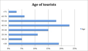
Figure 6: Age of tourists(VVV Texel, 2014)
2.1.1.4.Activities
The main motives to visit Texel are (in order of magnitude)(VVV Texel, 2014):
- Visit the beaches
- Walking
- Shopping/visit villages
- Dining
- Nature/visit Slufter
- Rest
- Cycling
Some groups think accessibility of the public space is the main criteria, as they are in wheelchairs or pushing a buggy. Other groups prefer safety, an example of this group is elderly people. Another group likes to walk through the nature and the villages of Texel. This requires dedicated walking paths. For especially tourists is it vital that signs are available. Meeting places require a different approach, but they are also essential for both the tourists and the Texelaars. Especially for the Texelaars it is important to move on the island by bike or car, so the public space should be arrange in a way that the mobility will not aggravate.
2.1.1.5.Liveability barometer
For multiple municipalities in the Netherlands, a 'liveability barometer' (in Dutch: Leefbaarometer) is created. Figure 7 shows the liveability barometer of Texel. Almost all areas score 'extremely positive', except for the area around Oosterend which scores 'very positive'. Public space is an important aspect of this barometer. Examples of public space are:
- Share of dilapidated buildings
- Noise pollution
- View on inland waters
- Value of rental houses
- Green space
- Etc.
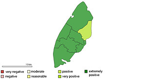
Figure 7: Liveability barometer Texel (Leefbarometer, 2014)
2.1.1.6.Municipality
The public spaces of Texel are not fully owned by their municipality. Various (environmental) organisations own and maintain a part of the island. However, within the villages of Texel, the municipality owns the majority of the public space. The construction and maintenance is organised and paid by the municipality. This means that the design proposal(s) should be within the means of the municipality.
2.1.1.7.Conclusion
In the conclusion the following question will be answered: "Who are actors, their problem definitions, needs, interests etc.?". The answer is categorized into three sections.
Actors
This group can be divided in users and owners/maintainers. One of the user groups, the Texelaars, is largely represented by people of the age 45+. During summer, the second group, tourists (of the about same age group) visit the island and use the public space as well. Of all groups, these two age groups will use the public space the most compared to other age groups. It is assumed that different age groups will use the public space differently. The focus lies on the age group of 45 years and older. Both the tourists and Texelaars are taken into account as users. The municipality is the owner and maintains the public space, so the design proposal(s) should be within the means of the municipality.
Problem definition
From the data above, it cannot be concluded that there is a specific area that needs to be improved, other than the public space within the villages. From the analysis of the actors it is not yet known which problems the inhabitants and tourist are facing with the public space of Texel. Additional research has to be performed on the current public space.
Needs and interests
Main attractions for visitors are the beaches and the villages. Walking is also a popular activity. If signs are necessary, they should be clear for both Dutch and German people. The percentage of people spending the night on camping sites increases. Therefore the sustainable public space could respond to this development. The people that spend more days on the island have place where they sleep and the people that only visit the island for one day don't. Therefore the people that will spend the night use the public space in a different way than tourists for one day.
It is very important that the public space especially during summer fulfils the needs of the actors because the number of people on the island almost doubles during high season.
According to the users (45+ for both tourists and Texelaars), the accessibility of the public space should be very important, together with safety. For Texelaars is mobility important, as well as a meeting place and identifying Texel in the public space (Loos, 2014). Tourists prefer the nature on the island that they want to experience.
2.1.2.Landscape
Public space is strongly related to the inherent landscape, because it is the space that 'remains' after the landscape is build on. Therefore, in this paragraph is the question "How is public space embedded in the landscape?" further examined. First, the landscape of Texel is analysed, following by an analysis of the 6 largest villages of Texel.
2.1.2.1.Stratification of Texel's landscape
The landscape of Texel is analysed according to Bobbink's (2009) method, which consists out of 4 layers:
- Landscape layer
- Cultural layer
- Urban layer
- Architectural adjustments
The first three layers are especially applicable for Texel and therefore analysed below.
Landscape layer
With landscape is meant the layer that is consisting out of the following components: the geomorphology, soil, water and vegetation (Bobbink, 2009). Texel is one of the scarce places in the Netherlands where this landscape layer still exists. Basically, the landscape layer cannot be unsustainable because no human intervention took place. The island is constantly changing in shape due to the influences of the water, wind, etc. However, at many areas on Texel is this layer adjusted to prevent the modification of Texel (by for example a polder).
The highest and oldest point (of 15 m) on Texel is situated between the villages of Den Burg and Oudeschild as can be seen in Figure 8. The Slufter is visible as the green area between the dunes on the north-western coast line. The lower parts of Texel are the "gulf areas", of a height between -1 and 1 N.A.P.
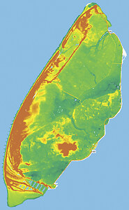
Figure 8: Elevation map of Texel (Actueel Hoogtebestand Nederland, 2014)
Cultural layer
The cultural layer is the modification of the landscape layer to adjust the area for agricultural use or water management. The shape of the way the land is drained, tells many things about for example the soil type, the period of draining, etc. Figure 9 and Figure 10 show a difference in the shapes of drained land. From this it can be concluded that the northern part of the island is cultivated by creating polders. This results in a straight parcelling of land, streets and houses. The southern part of Texel is called the "old land" of Texel and it consists out of many soil types. This resulted in an erratic parcelling that is still visible despite of the merging of parcels in the last 50 year. Some of these alterations can be marked as unsustainable.
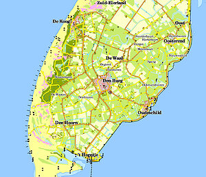
Figure 9: Southern part of Texel (TOP50, 2014)
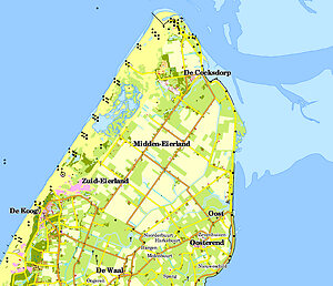
Figure 10: Northern part of Texel (TOP50, 2014)
Landscape Architects 4 sale (2007), distinguishes seven different landscape identities of Texel as can be seen in Figure 11. These identities are based on both the cultural and landscape layer. The "old land" characterizes itself by its erratic parcelling with a strong variation in agricultural land, woods and villages. It is the oldest part of Texel. The beach polders are derived by land reclaiming from the North sea during the 19th century (Ecomare, 2014). They consist out of a strict grid and wide planes. The sea polders are derived from the Wadden sea and smaller compared to the beach polders. They adjoin the "old land" from where they are drained from 1550 to 1877. The sea polders are more grid like compared to the "old land", however, this is hardly emphasized in these polders. The area northwest of the "old land" is called the inner dunes. It is a combination of the landside of the dunes and woods, which consist of more enclosed spaces compared to the other identities. There are no villages situated in the landscape identities flooding land, dunes and the sea strip. Because of the fact that our focus is on the villages of Texel, these other landscape identities are not considered in this analysis.
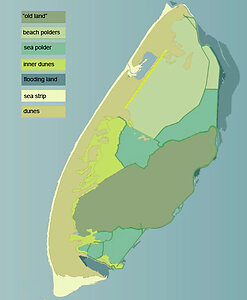
Figure 11: Landscape identities (la4sale & Gemeente Texel, 2007)
Urban layer
The urban layer is about the settlements within a landscape. These settlements arose on places where the conditions for living are beneficial (Bobbink, 2009). Texel consists out of seven villages and many neighbourhoods. However, only the villages that are considered in this analysis are:
- Cocksdorp
- De Koog
- Den Burg
- Den Hoorn
- Oosterend
- Oudeschild
The urban layer is related to (and often based on) the cultural and landscape layer. It is analysed to what extent these layers used to intervene and how that developed to the current urban layer.
2.1.2.2.De Koog
This village is situated on the inner dune area (Figure 12). It used to be a small village of a few streets next to the dunes, but after WWII the tourism caused the village to grow. Especially in the last decades of the previous century there are build a lot of accommodations for the tourists and for activities of the tourists. Unfortunately these expansions of De Koog do not ascribe the village as a "dune"-village, as they have their complete own identity (which is no identity) that does not match with De Koog its origin. In Figure 12 it can be seen that the holiday parks do not align with the dunes landscape. The authenticity of the De Koog is lost; the public space should include its landscape characteristics in order to become more sustainable for the future.
The sustainability of the current public space is very related to the identity of De Koog. A lot of noise pollution is produced by drunk tourist during the night. The bars and clubs contribute as well for the noise pollution. Waste is produced in all the public space surrounding holiday parks. Some dwellings are almost situated in the dunes, but the streets towards these houses do completely not align with the underlying landscape of the dunes and the woods. Furthermore, the nearby bungalow parks do not fit at all in the dune and polder landscape. (Gemeente Texel, 2009)
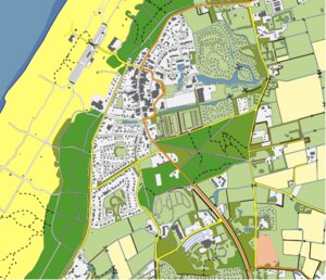
Figure 12: Map of De Koog (TOP10vector, 2014)
2.1.2.3.De Cocksdorp
The Cocksdorp is situated in Eierland, which is part of the 'beach polders'. The whole polder including the villages is designed upfront the dredging, and because of the fact that it is a polder, it is quite a young village. It is situated on the intersection of two roads, a sea dike and a dike next to the 'Roggesloot' and typically an example of a linear settlement. The main advantage of this type is the view towards the green environment of Texel. However, in the 80ies, the space between the two streets is cultivated as well with dwellings. This had also an impact on the public space of De Cocksdorp which became less green. The bungalow parks next to De Cocksdorp do not fit at all in the landscape, but as these parks are separated with the village by a busy road, it is not considered in the analysis. (Gemeente Texel, 2009)
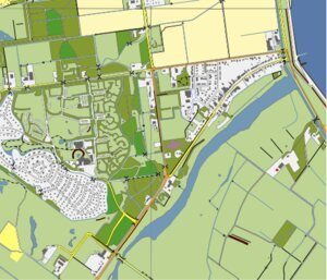
Figure 13: Map of Cocksdorp (TOP10vector, 2014)
2.1.2.4.Den Burg
Ringdorp
Den Burg is the largest village on Texel, counting more than 7000 residents. If you look at how the streets in Den Burg are laid out, the many stores and other central facilities, the village actually resembles a small city. In 1356, the residents of Den Burg constructed a 'burgh wall' surrounded by a 'burgh' moat. Within the walls of the rampart, the populated inner ring of Den Burg was founded. The moat was drained in 1902 and the wall has almost totally been replaced with houses. But you can still see the moat and wall in the round pattern that the streets form within this ring. In the center of Den Burg, weekly and tourist markets are held. The old Schouten House is still standing and the House of Antiquities is found in one of the old homes (Ecomare, 2014). Many activities are developed in Den Burg for tourists. For example, one can see many shopping, summer markets, activities – thematic markets, sales music in streets etc. It is also interlocutor of local politics (Winkelhart van Texel, 2014).
Den Burg hasn't always been the most important village on Texel. That used to be the village The Westen, but it no longer exists. In the 14th century, the governing center on Texel was moved to Den Burg and it still fulfils this role till this very day. You find the town hall and all kinds of other important establishments here, such as banks, the sole high school, the police station and the tourist office. (Ecomare, 2014)
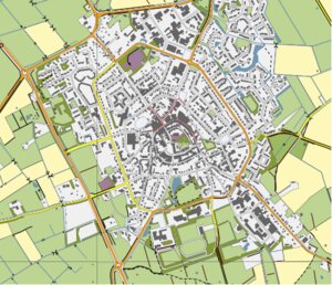
Figure 14: Map of Den Burg (TOP10vector, 2014)
2.1.2.5.Den Hoorn
The dike village Den Hoorn has two core values: cultural history and dynamic landscape.
Cultural-historical heritage
Den Hoorn played in the 17th and early 18th century an important role in piloting ships. Because Den Hoorn close to the sheltered cove Mug - Old Spanjaardsgat - is, it lent itself very well as pilot station. It is now also called as a village of pilots, after the monuments used during those times.
Dynamic landscape
The landscape around Den Hoorn has its origins in the ice ages. The glaciers pushed the boulder clay hill cliff and distant Mountain High to significant heights. A landscape that consists of a core of boulder clay (in Dutch: keileem) surrounded by a network of gullies and dunes, the so-called flood hooks. (VVV Texel, 2014) (Den Hoorn Promotie, 2014)
The preservation of these values is not obvious. The developments threaten the vitality and values of the area. Aging population and declining tourism revenues add the threat to viability and economics of the village and the surrounding areas.
Around 2004, a group of inhabitants of Den Hoorn gathered to think thoroughly about once the desired developments in and around the village and the south-western tip of the island. It concluded that "major maintenance" was necessary to keep the village and the surrounding vital and attractive for both residents and tourists. Backed by the county and the town became a "bottom-up process organized in which participated many residents and organizations, which resulted in the village development plan in 2006." Pilots by the Landscape. "This plan, which includes very clear and concrete choices for the desired developments in areas such as housing, tourism and landscape, was broadly and then unanimously adopted by the Texel council as a basis for policy for the further development of Den Hoorn.
All suggestions for development are inventoried from village development plan and judged on technical execution, planning and financial feasibility. Based on this, the most promising ideas were realised. The total program goes through a period of four years, from early 2013 to late 2016.
The following projects are in progress (Den Hoorn Promotie, 2014):
• Village Square: scenic transition
• Monumental nautical cottage
• Natural beach entrances
• Facade Brokers
• Neeltje Whore: restoring a striking dune
• Pilot Beacons: characteristic points in the landscape
• Pilot districts hiking
• Lagewegje: historical walking and cycling
• Open Air sheep and landscape
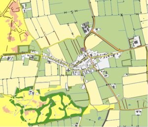
Figure 15: Map of Den Hoorn (TOP10vector, 2014)
2.1.2.6.Oosterend
Oosterend is the second largest village on the island and an example of a cluster village. One important thing about Oosterend is that although it's situated further from the sea than Oudeschild, it's the hometown of most fishermen on Texel.
What is more, Oosterend is built around a church called Maartenskerk ("Saint Martin's Church") that is located in the center of the village and it is one of the oldest churches in the Netherlands. The oldest parts of the church were built in the 11th century. Oosterend is sometimes called Jerusalem-of-the-north, this is caused due to five different religions in the village, Catholicism, Baptism, Dutch Reformed, Protestantism, Reformed-Gemeente. But this does not lead to conflicts, since all the religions live peacefully together. In fact, many people think that Oosterend is the most charming village on Texel, due to its picturesque little streets and their ancient façades surrounding the medieval Maartenskerk. What is more, this village is situated on the Wadden Sea, and it has some 1,300 inhabitants and several shops, some restaurants and a café, making the village a lively and cheerful place. Regarding public space aspects, it is also important to mention the Leitjes route, which is a charming walk through the ancient parts of Oosterend.
There are also some summer and winter activities within the village. For instance, a large flea market is held regularly in the summer, and during winter there is a Christmas Market, which always attracts lots of visitors. (Wikipedia, 2014) (VVV Texel, 2014)
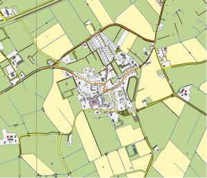
Figure 16: Map of Oosterend (TOP10vector, 2014)
2.1.2.7.Oudeschild
Oudeschild is the fishing harbour of the island, and it is situated at the Wadden Sea dike. The village is situated next to the sea and typically a dike village as the first dwelling where build next to the dike. Next to the harbour, the windmill Traanroeier marks the site of the Maritime and Beachcombers Museum, which shows collection of objects found on the beaches of Texel.
Regarding public space analysis it is important to mention that close to the village is the Hoge Berg, the "High Mountain", which is a 15-meter high hill. Near the Hoge Berg is the Russian's cemetery. Here lie the Georgians who died in their uprising in 1945.
In 2001, the town of Oudeschild had 1145 inhabitants, making it the fourth largest village in Texel. The built-up area of the town was 0.45 km², and contained 458 residences. The statistical area "Oudeschild", which also can include the peripheral parts of the village, as well as the surrounding countryside, has a population of around 1270.
What is more, Oudeschild is the home harbor of the Texel fishing fleet and its rough and ready charm makes it especially attractive to tourists. What is more, people can take a boat journey on the Wadden Sea. Besides, beachcombers are natural storytellers. They relish in telling the tales of their finds and adventures. As an attraction for tourist, people can explore traditional fishermen's houses and old seadogs give frequent rope making and fish smoking demonstrations. (Wikipedia, 2013) (VVV Texel, 2014)
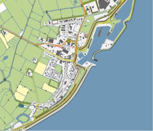
Figure 17: Map of Oudeschild (TOP10vector, 2014)
2.1.3.Technologies
Basically, public space could be created without technology. In fact, often is space created without technologies, and are the technologies added later on. Some examples of those additions are signs, lampposts, etc. These technologies are very common and became a part of the public space. The users won't recognise these features as a technology as it became part of the public space.
In some villages however, is made excessive use of signs (Figure 18). These signs are to direct the road but placed onto buildings as a shield, like a neon sign. In this case the technology prevailed.
Figure 18: Excessive use of signs in Den Burg (Gemeente Texel, 2009)
2.1.4.Rules and regulations
The most important document considering the rules and regulations of public space is the structural vision (Structuurvisie) of 2020 for the municipality of Texel. This document includes directions for future policies, so it does not includes rules or regulations. The vision is based on the core qualities of Texel, e.g. the feeling of space and peace and quiet, the nature and cultural landscapes, Texel's identity, darkness during the night, the solidarity between Texelaars, the insular economy etc. Because of the involvement of many inhabitants, the visions are hopefully recognisable and therefore also successful. The policy is divided over three topics: the economy, public space and environment and finally a thriving society. Only 'public space and the environment' is taken into account in this analysis. (Gemeente Texel, 2009)
Texel faced the last decade some changes in their population (more elderly people, less young adults, see paragraph 2.1.1.). This resulted in changing demands for the Texelaars. Several initiatives were drawn and constructed. The construction (and demolishing) of dwellings creates new public space. In the next decade, about 400 new dwellings are expected to be built. These dwellings will be located in such a way that the public space will align with the identity of the village and its surrounding landscape. If possible, the existing infrastructure will be used or based upon. The centre of the bigger villages (Den Burg and De Koog) are dedicated to pedestrians and cyclists, the future policy is to maintain this.
Bibliography
Actueel Hoogtebestand Nederland. (2014, 12 11). AHN Viewer. Retrieved 12 11, 2014 from Actueel Hoogtebestand Nederland: http://ahn.geodan.nl/ahn/
Avermaete, T. (2013). From unité to jussieu: the public realm as frame, substance and goal of architecture. In S. K. Dirk van den Heuvel, Delft Lecture series on architectural design , 102-117. Delft.
Bobbink, I. (2009). Land inZicht. Amsterdam: SUN.
CBS. (2014, 12 1). Factsheet huishoudens naar samenstelling. Retrieved 12 1, 2014 from Texel in cijfers: http://www.texel.incijfers.nl/Quickstep/QsReportAdvanced.aspx?report=fccbs_hhs
CBS. (2014, 11 21). Texel in cijfers - Bevolking. Retrieved 11 21, 2014 from Texel in cijfers: http://www.texel.incijfers.nl/
CBS. (2014, 11 21). Texel in cijfers - Werkeloosheid. Retrieved 11 21, 2014 from Texel in cijfers: http://www.texel.incijfers.nl/
Den Hoorn Promotie. (2014). Loodsen door het landschap. Retrieved 12 13, 2014 from Texel Den Hoorn: http://www.texeldenhoorn.nl/loodsproject
Ecomare. (2014). Den Burg. Retrieved 12 12, 2014 from Ecomare: http://www.ecomare.nl/en/encyclopedia/water-and-land/wadden-sea-region/dutch-wadden-region/texel/villages-on-texel/den-burg/
Ecomare. (2014, 12 12). Polders op Texel. Retrieved 12 12, 2014 from Ecomare: http://www.ecomare.nl/ecomare-encyclopedie/gebieden/waddengebied/nederlands-waddengebied/texel/polders-op-texel/
Ecomare. (2014, 12 1). Recreatie op Texel. Retrieved 12 1, 2014 from Ecomare: http://www.ecomare.nl/ecomare-encyclopedie/gebieden/waddengebied/nederlands-waddengebied/texel/recreatie-op-texel/
Ecomare. (2014, 12 1). Recreatie op Texel. Retrieved 12 1, 2014 from Ecomare: http://www.ecomare.nl/ecomare-encyclopedie/gebieden/waddengebied/nederlands-
Federal Office for Building and Regional Planning (BBR). (2006). Perspektive Flächenkreislaufwirtschaft special publications series for the ExWoSt research field Fläche im Kreis. Theoretische Grundlagen und Planspielkonzeption .
Ferber, U., & Preuss, T. (2006). Circular Flow Land Use Management: New Strategic, Planning and Instrumental Approaches for Mobilisation of Brownfields. Berlin: Deutsches Institut für Urbanistik.
Gameren, D. (2013). Revisions of space: positioning and repositioning space in and around buildings. In S. K. Dirk van den Heuvel, Delft lecture series on architectural design , 118-140. Delft.
Geels, F. (2004). From sectoral systems of innovation to socio-technical systems: Insights about dynamics and change from sociology and institutional theory. Research Policy , 33 (6-7), 897-920.
Gehl, J. (2011). Life Between Buildings: Using Public Space. New York: The Danisch Architectural Press.
Gehl, J. (2003, 07 25). Winning Back the Public Spaces. Barcelona.
Gemeente Texel. (2007). Beeld van Texel. Texel: la4sale.
Gemeente Texel. (2009). Texel op koers - Structuurvisie 2020. Texel.
Gemeente Texel. (2009). Texel op koers - Structuurvisie 2020. Texel: la4sale.
Huang, B., Ouyang, Z., Zheng, H., Zhang, H., & Wang, X. (2008). Construction of an eco-island: A case study of Chongming Island China. Ocean & Coastal Management , 51 (8-9), 575-588.
IETU. (2010). CircUse. Retrieved 11 21, 2014 from Circular Flow Land Use Management (CircUse): http://www.circuse.eu/index.php?s=1
la4sale & Gemeente Texel. (2007). Beeld van Texel. Amsterdam: Fokker.
Leefbarometer. (2014, 12 1). Leefbaarometer. Retrieved 12 1, 2014 from Leefbaarometer: http://www.leefbaarometer.nl/leefbaarheidskaarten;jsessionid=F79E5E3EC4EF1F3DDF57A6E3D9595355
Loos, B. (2014, 11 20). Texel. (T. Zeinstra, Interviewer)
Samenwerkingsverband Nationale Parken. (2014, 12 1). Dutch Nature Policy. Retrieved 12 1, 2014 from Samenwerkingsverband Nationale Parken: http://www.nationaalpark.nl/documents/nationale-parken/nederlands-natuurbeleid.xml?lang=en
Texelse Courant. (2013, 01 17). Texelaars beginnen met Texel Team 2020. Retrieved 01 02, 2015 from Texelse Courant: http://www.texelsecourant.nl/lees/14725/texelaars-beginnen-met-texel-team-2020
TOP10vector. (2014, 12 11). Maps TU Delft. Retrieved 12 11, 2014 from Maps TU Delft: https://maps.tudelft.nl/index.php
TOP50. (2014, 12 11). Maps TU Delft. Retrieved 12 11, 2014 from Maps TU Delft: https://maps.tudelft.nl/index.php
UNESCO. (2014). UNESCO statement: ECOSOC Integration Segment on Sustainable Urbanization. Retrieved 11 21, 2014 from United Nations: http://www.un.org/en/ecosoc/integration/pdf/unesco.pdf
VVV Texel. (2014). Den Hoorn. Retrieved 12 13, 2014 from Texel: http://www.texel.net/nl/over-texel/dorpen/den-hoorn/
VVV Texel. (2014, 12 1). Factsheet toerisme op Texel 2014. Retrieved 12 1, 2014 from Texel: http://www.texel.net/nl/voor-de-pers/wist-je-dat-van-texel/
VVV Texel. (2014). Oosterend. Retrieved 12 12, 2014 from Texel: http://www.texel.net/en/about-texel/villages/oosterend/
VVV Texel. (2014). Oudeschild. Retrieved 12 12, 2014 from Texel: http://www.texel.net/en/about-texel/villages/oudeschild/
Waddenfonds. (2013, 04 13). Project Veilig en verlicht Texel. Retrieved 01 02, 2015 from Waddenfonds: http://www.waddenfonds.nl/Projecten_detail.2918+M5be7fe8a8e3.0.html
Wikipedia. (2014, 05 24). Oosterend. Retrieved 12 12, 2014 from Wikipedia: http://en.wikipedia.org/wiki/Oosterend
Wikipedia. (2013, 11 19). Oudeschild. Retrieved 12 12, 2014 from Wikipedia: http://en.wikipedia.org/wiki/Oudeschild
Winkelhart van Texel. (2014). Den Burg. Retrieved 12 13, 2014 from Winkelhart van Texel: http://www.winkelhartvantexel.nl/