Stratification of Texel's landscape
The landscape of Texel is analysed according to Bobbink's (2009) method, which consists out of 4 layers:
- Landscape layer
- Cultural layer
- Urban layer
- Architectural adjustments
The first three layers are especially applicable for Texel and therefore analysed below.
Landscape layer
With landscape is meant the layer that is consisting out of the following components: the geomorphology, soil, water and vegetation (Bobbink, 2009). Texel is one of the scarce places in the Netherlands where this landscape layer still exists. The island is constantly changing in shape due to the influences of the water, wind, etc. However, at many areas on Texel is this layer adjusted to prevent the modification of Texel (by for example a polder).
The highest and oldest point (of 15 m) on Texel is situated between the villages of Den Burg and Oudeschild as can be seen in Figure 1. The Slufter is visible as the green area between the dunes on the north-western coast line. The lower parts of Texel are the "gulf areas", of a height between -1 and 1 N.A.P.
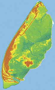
Figure 1: Elevation map of Texel (Actueel Hoogtebestand Nederland, 2014)
Cultural layer
The cultural layer is the modification of the landscape layer to adjust the area for agricultural use or water management. The shape of the way the land is drained, tells many things about for example the soil type, the period of draining, etc. Figure 2 and Figure 3 show a difference in the shapes of drained land. From this it can be concluded that the northern part of the island is cultivated by creating polders. This results in a straight parcelling of land, streets and houses. The southern part of Texel is called the "old land" of Texel and it consists out of many soil types. This resulted in an erratic parcelling that is still visible despite of the merging of parcels in the last 50 year.
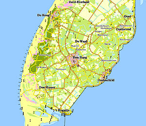
Figure 2: Southern part of Texel (TOP50, 2014)
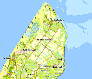
Figure 3: Northern part of Texel (TOP50, 2014)
Landscape Architects 4 sale (2007), distinguish seven different landscape identities of Texel as can be seen in Figure 4. These identities are based on both the cultural and landscape layer. The "old land" characterizes itself by its erratic parcelling with a strong variation in agricultural land, woods and villages. It is the oldest part of Texel. The beach polders are derived by land reclaiming from the North sea during the 19th century (Ecomare, 2014). They consist out of a strict grid and wide planes. The sea polders are derived from the Wadden sea and smaller compared to the beach polders. They adjoin the "old land" from where they are drained from 1550 to 1877. The sea polders are more grid like compared to the "old land", however, this is hardly emphasized in these polders. The area northwest of the "old land" is called the inner dunes. It is a combination of the landside of the dunes and woods, which consist of more enclosed spaces compared to the other identities. There are no villages situated in the landscape identities flooding land, dunes and the sea strip. Because of the fact that our focus is on the villages of Texel, these other landscape identities are not considered in this analysis.
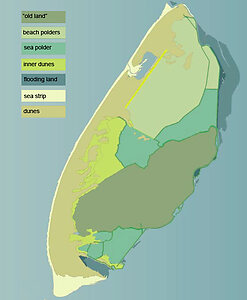
Figure 4: Landscape identities (la4sale & Gemeente Texel, 2007)