PUBLIC SPACE - General introduction
 Pinal Desai,
 Tatiana Armijos Moya
Introduction of Public Space
Public Space
The sub-system public space is one out of eight sub-systems that are analyzed in order to perform a sustainable transition of the Dutch island of Texel. The other seven sub-systems have the same goal of transforming Texel into a sustainable island. Besides, each of these sub-systems is - to some extent - related to each other.
Texel is the biggest island out of 5 Wadden islands and situated in the province of Noord-Holland, The Netherlands. It is enclosed by the North Sea and the Wadden Sea and accessible by a ferry. The island has about 13,000 inhabitants spread over several villages. During summertime it is very crowded with tourists from both the Netherlands and Germany.
A public space is a social space that is generally open and accessible to people, or a collective area that is shaped within the building mass improving the connection between the building and its surroundings and prevent the city from being reduced to uniform public space and or uniform closed building masses. In fact, within these transitional areas different kind of activities are developed such as walking, staying, sitting, seeing, hearing, talking, among others. Furthermore, regarding urban scale, public space can be defined as the connecting spaces that organize the relation between the buildings and the city. Therefore, public space is defined as the life or space between buildings where people can share with others and with the city in a relaxed and undemanding way.
What is more, several thinkers have attempted to describe the characteristics of the modern public space. For instance, the German philosopher Jürgen Habermas defines the term Öffentlichkeit, ‘the public realm’ ‘public space’, as ‘a realm of social life in which something approaching public opinion can be formed ... and in which citizens can confer in an unrestrictive manner’. He defines this realm as a social area where rational discussion takes place between citizens regarding general interests.
In order to understand the importance of the existence of public spaces, it is important to establish that people generally want the buildings that represent their social and community life to give more than functional fulfillment. They want their aim for monumentality, happiness, pride, and excitement to be satisfied. That is why the spaces and the movements that link those buildings and its surroundings are essential, because they have to achieve the same goal of fulfillment between the people and the city.
Finally, it is important to mention that people are attracted to other people. It is commonly factual that people and human activities attract other people. Generally, people gather with and move about with others and seek to place themselves near others. New activities begin in the vicinity of events that are already in progress. (Gehl, 2011) (Gameren, 2013) (Avermaete, 2013)
The chapter of the sub-system public space consist out of several paragraphs. The challenges and ambitions that lead to a problem statement and research question are discussed in the introduction. In the next two paragraphs are the current and the future (sub-)system discussed including topics as actors, technologies and regulations. These two (sub-)systems are compared in the fourth paragraph. Concluding from the comparison, a proposal is drawn up. Finally, the proposal for the sustainable transition of the sub-system public space is evaluated in relation to the other sub-systems.
Bibliography
Habermas, J. (1974). The Structural Transformation of the Public Realm, For a detailed discussion of the concept of the public realm in the work of Jürgen Habermas, see Peter Hohendahl & Patricia Russian, ‘Jürgen Habermas: “The Public Realm” (1964)’ , in: New German Critique, no. 3 (Autumn, 1974), pp 45-48.
Avermaete, T. (2013). From unité to jussieu: the public realm as frame, substance and goal of architecture. In S. K. Dirk van den Heuvel, Delft Lecture series on architectural design , 102-117. Delft.
Gameren, D. (2013). Revisions of space: positioning and repositioning space in and around buildings. In S. K. Dirk van den Heuvel, Delft lecture series on architectural design , 118-140. Delft.
Gehl, J. (2011). Life Between Buildings: Using Public Space. New York: The Danisch Architectural Press.
PUBLIC SPACE - Introduction

1. Introduction
1.1. Socio-technical system
1.2. (Un)sustainabilities
1.3. Societal needs
1.4. Sustainable criteria
1. Introduction
1.1. Socio-technical system
1.2. (Un)sustainabilities
1.3. Societal needs
1.4. Sustainable criteria
1. Introduction
The island of Texel has the ambition to be self-supporting in the field of energy in 2020 (Texelse Courant, 2013). Several initiatives are already implemented to achieve this transition, in the field of public space as well as the other sub-systems. For example, concerning public space there will be a sustainable streetlight plan implemented to decrease the amount of energy used for public lightning and increase the safety of the users (Waddenfonds, 2013). However, the goal of this course is not equal to the ambition of being self-supporting by 2020. This research focuses on achieving a sustainable transition on Texel and this should be achieved by designing the public space of Texel as a socio-technical system (Geels, 2004).
Texel consists out of several small villages. The term 'public space' is often used in relation to spaces in large cities. In the case of Texel, the term 'public space' is related to small villages and the surrounding landscape. The North Sea and Wadden Sea are not included in the scope public space, which consist of all public spaces on Texel that are accessible on foot. What is peculiar about Texel is that a lot of tourists visit the island during summertime. Therefore the public space is both used by the inhabitants of Texel and the tourists. Currently the public space is mainly adapted to the tourists, as most of the Texelaars earn their money from them. Generally does the public space not contribute to a sustainable Texel. Many spaces are adapted to the well-being of tourists and because of that, the quality of the public space became worse.
1.1.Socio-technical system
Many municipalities, countries etc. aim to optimize their systems for efficiency and accomplishing carbon-neutrality. However, in order to produce a sustainable urban environment it is necessary to generate a change of citizens’ minds. What is more, environmentally friendly technologies and strategies need to be supported by the integration of cultural, social, educational and environmental policies that create the ethical and intellectual knowledge, skills, attitudes and behaviours of citizens. Geels (2004) describes this resistance and proposes the socio-technical system as a solution to the answer of the transition towards sustainability. Figure 1 describes that if a change needs to be accomplished, the current socio-technical regime is resistant to this change. However, if the socio-technical regime has some tensions ("windows of opportunity"), it could be possible that a new socio-technical system fills those gaps and replaces the old regime, together with other changes in the society. The replacement of the system will influence the 'landscape,' which in this case is desirable to result in a sustainable transition of Texel.
Figure 1: A dynamic multi-level perspective on system innovations (Geels, 2004)
The current socio-technical system of the public space of Texel is discussed in Paragraph 2.1.
1.2.(Un)sustainabilities
The public space of Texel can be categorized in various ways. First, public space can be divided in public space and semi-public space. An example of semi-public space is terrain of a bungalow park, which is owned by the bungalow park owner but accessible for the tourists. Both categories are taken into account, because both types of public space influence the sustainability of Texel.
Second, a difference can be made between the public space within the villages and the public space outside the villages. The focus of this research is on the public space within the villages, as this is transformed more compared to the public space outside the villages.
Traditionally the public space has three core functions, namely: meeting place, market place and traffic place (Gehl, 2003). The last few centuries this balance has somewhat shifted towards public space as a traffic place. The public space can be analysed from a 3P (People, Planet, Profit) perspective in order to understand what a sustainable public space is.
Table 1: Public space analysed from a 3P perspective
|
People |
Planet |
Profit |
|
Public safety |
Air quality |
Construction costs |
|
Attractive (both for commercial activities and nature activities) |
Emissions |
Maintenance costs |
|
Attractive (both for inhabitants and tourists) |
Waste reduction/recycling |
Transport infrastructure |
|
|
Native species |
Attractive for tourists |
|
|
Energy neutral (renewable energy) |
Local commerce |
|
|
Land use (spatial planning) |
|
An example of a solution that is currently performed in practice is public lightning. This solution increases the safety during the evening and night, is energy neutral because of low energy use in combination with solar panels and has less running costs because of the low energy use.
It appears that the aspects mentioned in Table 1 are not very poor but neither they are perfect. A combination of several aspects seems to be a possible solution for a future socio-technical system. These aspects will be discussed in the subsequent paragraphs.
1.3.Societal needs
Two groups can be distinguished when discussing the societal needs: tourists and inhabitants. Both groups make use of the same public space but have slightly different priorities concerning the aspects mentioned in Table 1. However, the sub-system public space has to fulfil the needs of both groups.
Tourists would prefer attractive public spaces where many activities (e.g. leisure, shopping) are located. Besides, many tourists come to Texel to visit the beautiful nature of the island. Despite of the fact that only the public space within the villages are considered in this research, the beauty of the nature of Texel should not be ignored in the public space of the villages. In fact, the surrounding nature of the villages should be emphasized in order to embed the village in the nature of Texel. This solution could be the answer for many needs like attractive place to stay, public safety, green environment, waste reduction, etc.
The inhabitants of Texel have the ambition to become energy neutral in 2020. However, their income depends for a large part on the expenses of the tourists. Therefore, the transition towards a sustainable Texel should not be at the expense of the tourists. So, what the tourists want, is what the Texelaars want. Besides, they prefer a good transport infrastructure, they are proud of the nature of Texel and they are quite involved in the topic of land use. As mentioned in paragraph 1.2 one of the three main functions of public space is meet each other. As stated in the policy vision for 2020 (Gemeente Texel, 2009), Texelaars are closely related to each other and to the island. The meeting places should therefore reflect the identity of Texel. Also because of the scale of Texel, there is still a kind of social control, which is strongly related to public safety.
1.4.Sustainable criteria
According to Huang Baorong, Ouyang Zhiyun, Zheng Hua and others (2008) in their scientific article Construction of an eco-island: A case study of Chongming Island, China; it was stated that Eco-island is a sustainable concept characterized by integrating ecosystem structure and function, by a powerful ecological security defence system, by a sustainable use of natural resources, by a prosperous and stable eco-economy, by creating comfortable human habitats and by producing an extensive ecological civilization.
Regarding Public Space sub-system within “Texel Sustainable Island” project, it is important to consider these six characteristics of eco-island concept, especially the creation comfortable human habits, the integration ecosystem structures and functions and the development of prosperous and stable eco-economy as a consequence. This is closely related to the 3P aspects derived from Table 1. Moreover, Huang (2008) established that a good natural environment is the basis for comfortable human habitats, and it requires suitable physical and climate conditions, high environmental quality, secure food supply, high quality of natural ecosystem services, low risk of natural disasters, and pleasant landscape. What is more, it was stated that a good social and economic environments are extremely essential because they are related with the concept of people’s welfare. (Huang, Ouyang, Zheng, Zhang, & Wang, 2008)
Furthermore, in order to generate a sustainable public space it is important to consider some aspects such as a well-planned city layout, public transportation, promoting voluntary simplicity in lifestyle choices, decreasing material consumption, and increasing awareness of environmental and sustainability issues. Thus, generating a sustainable urban environment within the island.
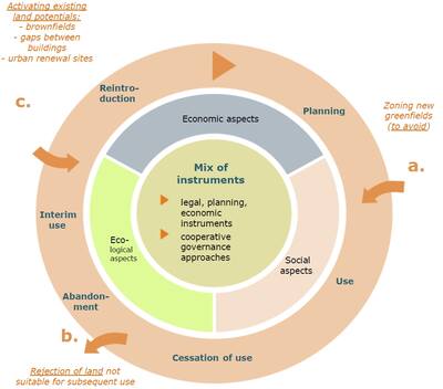
The aim is to create a smart island that supports sustainable strategies in order to generate people’s welfare. Regarding all these aspects it is proposed to integrate a Circular Flow Land Use Management strategy.
Circular flow land use management concept represents a different philosophy of land use, based on “avoid – recycle – compensate”. This strategy allows the use of green areas under specific conditions, but primarily and systematically seeks to use the potential of all existing locations. (Ferber & Preuss, 2006)
- Avoid:
The conversion of now unbuilt open space or agricultural land into new developments is to be avoided. - Recycle:
Areas with uses that were once active and now exhibit no viable use should be recycled by either introducing new uses or through renaturation. - Compensate:
Compensation should be required when construction must take place on previously unbuilt land. This can be in the form of renaturation projects or through de-sealing measures in built areas, where soil sealing is no longer necessary. (IETU, 2010)
Figure 2: Avoid - recycle - compensate (Federal Office for Building and Regional Planning (BBR), 2006)
The avoid-recycle-compensate (ARC) concept focuses especially on land use in order to generate a sustainable 'urban' environment. Hence, the sustainable criteria for public space are closely related to land use. The sustainable criteria for the public space within the villages of Texel are listed and explained below.
- Texel's identity:
Texelaars are closely related to the island. If the public spaces are linked to the identity of Texel, it is likely that the Texelaars will support this. The specific identity of each village should be determined together with its inhabitants. When inhabitants are involved in their neighbourhood, they are willing to do more effort to increase or maintain the liveability of that specific place. This includes for example the maintenance of public space. In conclusion, the public space is more durable and the transition towards the new public space is sooner accepted. Besides, the maintenance costs can be lower because of the involvement and cooperation of the inhabitants. - Pollution:
There are many kinds of pollution in the public space. One of the main polluters are the emissions emitted by vehicles and buildings. This decreases the air quality despite of the fact that the air quality in the villages of Texel is way better than many other Dutch cities. The tourists come to Texel to e.g. enjoy the nature. Therefore it is important that this pollution is avoided. Besides the reduction of emissions, waste and sound pollution should also be avoided as much as possible. Sound pollution originates from various sources, e.g. cars, agricultural vehicles, bars & restaurants, noisy tourists etc. Not all sources can be influenced equally. Waste pollution results mainly from the tourists and their related activities. - Attractiveness:
One of the main criteria for public space is that it should be attractive, otherwise it would not be used. In combination with the fact that tourists are appreciating the nature of Texel and the Texelaars that are closely related to the island, the villages should contain more natural (from Texel) elements in the public space. The attractiveness of the public space should also increase the profit element of 3P. - Safety:
The well-being and safety of people is an important factor for the choice to visit or stay at a certain public space or not. Therefore the success of a public space depends also on safety factors. Examples of these factors are darkness, visibility (blind spots), etc.
Bibliography
Federal Office for Building and Regional Planning (BBR). (2006). Perspektive Flächenkreislaufwirtschaft special publications series for the ExWoSt research field Fläche im Kreis. Theoretische Grundlagen und Planspielkonzeption .
Ferber, U., & Preuss, T. (2006). Circular Flow Land Use Management: New Strategic, Planning and Instrumental Approaches for Mobilisation of Brownfields. Berlin: Deutsches Institut für Urbanistik.
Geels, F. (2004). From sectoral systems of innovation to socio-technical systems: Insights about dynamics and change from sociology and institutional theory. Research Policy , 33 (6-7), 897-920.
Gehl, J. (2003, 07 25). Winning Back the Public Spaces. Barcelona.
Gemeente Texel. (2009). Texel op koers - Structuurvisie 2020. Texel.
Huang, B., Ouyang, Z., Zheng, H., Zhang, H., & Wang, X. (2008). Construction of an eco-island: A case study of Chongming Island China. Ocean & Coastal Management , 51 (8-9), 575-588.
IETU. (2010). CircUse. Retrieved 11 21, 2014 from Circular Flow Land Use Management (CircUse): http://www.circuse.eu/index.php?s=1
Texelse Courant. (2013, 01 17). Texelaars beginnen met Texel Team 2020. Retrieved 01 02, 2015 from Texelse Courant: http://www.texelsecourant.nl/lees/14725/texelaars-beginnen-met-texel-team-2020
UNESCO. (2014). UNESCO statement: ECOSOC Integration Segment on Sustainable Urbanization. Retrieved 11 21, 2014 from United Nations: http://www.un.org/en/ecosoc/integration/pdf/unesco.pdf
Waddenfonds. (2013, 04 13). Project Veilig en verlicht Texel. Retrieved 01 02, 2015 from Waddenfonds: http://www.waddenfonds.nl/Projecten_detail.2918+M5be7fe8a8e3.0.html
PUBLIC SPACE - Current system

2. Current system
2.1. Socio-technical system
2.1.1. Actors
2.1.2. Landscape
2.1.3. Technologies
2.1.4. Rules & Regulations
2.2. Unsustainable mechanisms
2.3. Trends
2.4. Conclusion
2. Current system
2.1. Socio-technical system
2.1.1. Actors
2.1.2. Landscape
2.1.3. Technologies
2.1.4. Rules & Regulations
2.2. Unsustainable mechanisms
2.3. Trends
2.4. Conclusion
2. Current system
In order to design a sustainable public space for Texel, the current system is analysed on the basis of a socio-technical system. Several unsustainabilities and trends resulted from the analysis of the socio-technical system of public space and a conclusion is drawn based on the analysis.
2.1. Socio-technical system
The difference between a socio-technical system and the common sectoral systems is that the fulfilment of societal functions is central in a socio-technical system (ST-system). The sectoral system focuses especially on the development of knowledge and not on the use of technology. The focus of a ST-system is on both innovations and functionality. To achieve change in the current public space, the current dominant system has to change as well. However, this dominant system is always resistant to change. The approach of a ST-system results in a combination of technological niches that together form a new ST-system that replaces the current ST-system by taking advantage of 'windows of opportunity'. (Geels, 2004)
The subsystems of this regime (actors, landscape, technologies, rules & regulations, etc.) are analysed in this section to get to know the current ST-regime and rising trends. Public space is closely related to functionality. In comparison with for example the sub-system 'water' it involves less technologies.
2.1.1.Actors
The first subsystem of the regime that is discussed, are the actors. Users of public space involve inhabitants of Texel and tourists visiting Texel. The public space is owned and maintained by the municipality of Texel.
In the following paragraphs is elaborated on the statistics concerning the users of the public space of Texel. The population of Texel and their tourists are analysed and conclusions are drawn for the implementation of a sustainable public space. The question "Who are actors, their problem definitions, needs, interests etc.?" will be answered in this chapter.
2.1.1.1.Population
Texel has about 13.500 inhabitants. The population of Texel is differing from the population in the Netherlands. The most noticeable fact is the high percentage of inhabitants above 50 years, which is higher for every age group above the 50. This means that there live relatively a lot of elderly people. Another fact that cannot be ignored, are the few people on the island between the 20 and 40 years old. Probably this is related to the opportunities for study and work. The small amount of children between 0 and 10 is probably due to the fact that their parents, the group of people between 20 and 40 years old, are neither living on the island.
The groups that especially should be considered for designing the public space are the elderly people (above 50 years). The group of teenagers should also be taken into account because they are representing the second group of Texel.
Figure 1: Population of Texelaars (CBS, 2014)
The second graph (Figure 2) shows the variation in population during one year. The natural growth and decline is equal to the growth in municipalities with the same characteristics. However, the migration numbers are clearly higher during spring and lower during fall. This has mainly to do with the fact that people who own a summer cottage move during the high season (summer) to Texel.
Figure 2: Population Texel (CBS, 2014)
The distribution of the households is slightly different compared to similar municipalities. Texel has a slightly higher percentage of single households. The number of cohabits with children is about 8% smaller and the number of single households slightly higher (Figure 3).
Figure 3: Distribution of households (CBS, 2014)
2.1.1.2.Unemployment
The unemployment rates (unemployed people looking for work) increases during the winter season (Figure 4). During summer these rates are similar to municipalities with same characteristics. There is a clear sine visible in this graph, which could easily related to the economy that is especially based on tourism and agriculture. What is not mentioned in this graph is the amount of hours working during the season. It is likely that during the summer a lot more working hours are made compared to the winter.
Figure 4: Unemployment of Texelaars (CBS, 2014)
2.1.1.3.Tourism
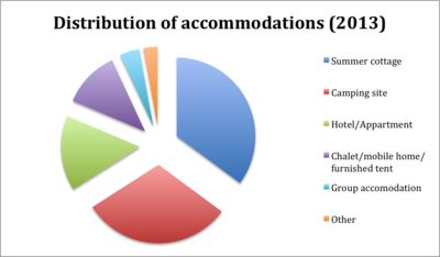
Every year, approximately 800.000 tourists a year visit Texel (Ecomare, 2014). A lot of them spend the night as well for a couple of days. The average number of nights tourists spend on the island is 4,7 nights, which is decreased compared to 2007. About 44.000 places are available where people can spend their nights. The distribution of these accommodations can be found in Figure 5. In ten years, the number of accommodations increased by 7,8%, especially because of the increase in camping sites. Almost 80% of the visitors already visited the island, so the number of returns is high. (VVV Texel, 2014)
Figure 5: Distribution of accommodations (VVV Texel, 2014)
Figure 6 shows that the largest group of tourists contains especially people from the age group 45-64 years. Teenagers are the second largest age group. About two-thirds of the tourists come from the Netherlands; the other part is represented by people from Germany.(VVV Texel, 2014) It is assumed that people from different age groups have varying preferences for the sub-system public space. For example, different age groups use the public space on different times. Teenagers will also use the public space during the night while elderly people will use the public space mainly during daytime. The activities in the public space of these age groups can vary as well, which is discussed in the following paragraph.
Figure 6: Age of tourists(VVV Texel, 2014)
2.1.1.4.Activities
The main motives to visit Texel are (in order of magnitude)(VVV Texel, 2014):
- Visit the beaches
- Walking
- Shopping/visit villages
- Dining
- Nature/visit Slufter
- Rest
- Cycling
Some groups think accessibility of the public space is the main criteria, as they are in wheelchairs or pushing a buggy. Other groups prefer safety, an example of this group is elderly people. Another group likes to walk through the nature and the villages of Texel. This requires dedicated walking paths. For especially tourists is it vital that signs are available. Meeting places require a different approach, but they are also essential for both the tourists and the Texelaars. Especially for the Texelaars it is important to move on the island by bike or car, so the public space should be arrange in a way that the mobility will not aggravate.
2.1.1.5.Liveability barometer
For multiple municipalities in the Netherlands, a 'liveability barometer' (in Dutch: Leefbaarometer) is created. Figure 7 shows the liveability barometer of Texel. Almost all areas score 'extremely positive', except for the area around Oosterend which scores 'very positive'. Public space is an important aspect of this barometer. Examples of public space are:
- Share of dilapidated buildings
- Noise pollution
- View on inland waters
- Value of rental houses
- Green space
- Etc.
Figure 7: Liveability barometer Texel (Leefbarometer, 2014)
2.1.1.6.Municipality
The public spaces of Texel are not fully owned by their municipality. Various (environmental) organisations own and maintain a part of the island. However, within the villages of Texel, the municipality owns the majority of the public space. The construction and maintenance is organised and paid by the municipality. This means that the design proposal(s) should be within the means of the municipality.
2.1.1.7.Conclusion
In the conclusion the following question will be answered: "Who are actors, their problem definitions, needs, interests etc.?". The answer is categorized into three sections.
Actors
This group can be divided in users and owners/maintainers. One of the user groups, the Texelaars, is largely represented by people of the age 45+. During summer, the second group, tourists (of the about same age group) visit the island and use the public space as well. Of all groups, these two age groups will use the public space the most compared to other age groups. It is assumed that different age groups will use the public space differently. The focus lies on the age group of 45 years and older. Both the tourists and Texelaars are taken into account as users. The municipality is the owner and maintains the public space, so the design proposal(s) should be within the means of the municipality.
Problem definition
From the data above, it cannot be concluded that there is a specific area that needs to be improved, other than the public space within the villages. From the analysis of the actors it is not yet known which problems the inhabitants and tourist are facing with the public space of Texel. Additional research has to be performed on the current public space.
Needs and interests
Main attractions for visitors are the beaches and the villages. Walking is also a popular activity. If signs are necessary, they should be clear for both Dutch and German people. The percentage of people spending the night on camping sites increases. Therefore the sustainable public space could respond to this development. The people that spend more days on the island have place where they sleep and the people that only visit the island for one day don't. Therefore the people that will spend the night use the public space in a different way than tourists for one day.
It is very important that the public space especially during summer fulfils the needs of the actors because the number of people on the island almost doubles during high season.
According to the users (45+ for both tourists and Texelaars), the accessibility of the public space should be very important, together with safety. For Texelaars is mobility important, as well as a meeting place and identifying Texel in the public space (Loos, 2014). Tourists prefer the nature on the island that they want to experience.
2.1.2.Landscape
Public space is strongly related to the inherent landscape, because it is the space that 'remains' after the landscape is build on. Therefore, in this paragraph is the question "How is public space embedded in the landscape?" further examined. First, the landscape of Texel is analysed, following by an analysis of the 6 largest villages of Texel.
2.1.2.1.Stratification of Texel's landscape
The landscape of Texel is analysed according to Bobbink's (2009) method, which consists out of 4 layers:
- Landscape layer
- Cultural layer
- Urban layer
- Architectural adjustments
The first three layers are especially applicable for Texel and therefore analysed below.
Landscape layer
With landscape is meant the layer that is consisting out of the following components: the geomorphology, soil, water and vegetation (Bobbink, 2009). Texel is one of the scarce places in the Netherlands where this landscape layer still exists. Basically, the landscape layer cannot be unsustainable because no human intervention took place. The island is constantly changing in shape due to the influences of the water, wind, etc. However, at many areas on Texel is this layer adjusted to prevent the modification of Texel (by for example a polder).
The highest and oldest point (of 15 m) on Texel is situated between the villages of Den Burg and Oudeschild as can be seen in Figure 8. The Slufter is visible as the green area between the dunes on the north-western coast line. The lower parts of Texel are the "gulf areas", of a height between -1 and 1 N.A.P.
Figure 8: Elevation map of Texel (Actueel Hoogtebestand Nederland, 2014)
Cultural layer
The cultural layer is the modification of the landscape layer to adjust the area for agricultural use or water management. The shape of the way the land is drained, tells many things about for example the soil type, the period of draining, etc. Figure 9 and Figure 10 show a difference in the shapes of drained land. From this it can be concluded that the northern part of the island is cultivated by creating polders. This results in a straight parcelling of land, streets and houses. The southern part of Texel is called the "old land" of Texel and it consists out of many soil types. This resulted in an erratic parcelling that is still visible despite of the merging of parcels in the last 50 year. Some of these alterations can be marked as unsustainable.
Figure 9: Southern part of Texel (TOP50, 2014)
Figure 10: Northern part of Texel (TOP50, 2014)
Landscape Architects 4 sale (2007), distinguishes seven different landscape identities of Texel as can be seen in Figure 11. These identities are based on both the cultural and landscape layer. The "old land" characterizes itself by its erratic parcelling with a strong variation in agricultural land, woods and villages. It is the oldest part of Texel. The beach polders are derived by land reclaiming from the North sea during the 19th century (Ecomare, 2014). They consist out of a strict grid and wide planes. The sea polders are derived from the Wadden sea and smaller compared to the beach polders. They adjoin the "old land" from where they are drained from 1550 to 1877. The sea polders are more grid like compared to the "old land", however, this is hardly emphasized in these polders. The area northwest of the "old land" is called the inner dunes. It is a combination of the landside of the dunes and woods, which consist of more enclosed spaces compared to the other identities. There are no villages situated in the landscape identities flooding land, dunes and the sea strip. Because of the fact that our focus is on the villages of Texel, these other landscape identities are not considered in this analysis.
Figure 11: Landscape identities (la4sale & Gemeente Texel, 2007)
Urban layer
The urban layer is about the settlements within a landscape. These settlements arose on places where the conditions for living are beneficial (Bobbink, 2009). Texel consists out of seven villages and many neighbourhoods. However, only the villages that are considered in this analysis are:
- Cocksdorp
- De Koog
- Den Burg
- Den Hoorn
- Oosterend
- Oudeschild
The urban layer is related to (and often based on) the cultural and landscape layer. It is analysed to what extent these layers used to intervene and how that developed to the current urban layer.
2.1.2.2.De Koog
This village is situated on the inner dune area (Figure 12). It used to be a small village of a few streets next to the dunes, but after WWII the tourism caused the village to grow. Especially in the last decades of the previous century there are build a lot of accommodations for the tourists and for activities of the tourists. Unfortunately these expansions of De Koog do not ascribe the village as a "dune"-village, as they have their complete own identity (which is no identity) that does not match with De Koog its origin. In Figure 12 it can be seen that the holiday parks do not align with the dunes landscape. The authenticity of the De Koog is lost; the public space should include its landscape characteristics in order to become more sustainable for the future.
The sustainability of the current public space is very related to the identity of De Koog. A lot of noise pollution is produced by drunk tourist during the night. The bars and clubs contribute as well for the noise pollution. Waste is produced in all the public space surrounding holiday parks. Some dwellings are almost situated in the dunes, but the streets towards these houses do completely not align with the underlying landscape of the dunes and the woods. Furthermore, the nearby bungalow parks do not fit at all in the dune and polder landscape. (Gemeente Texel, 2009)
Figure 12: Map of De Koog (TOP10vector, 2014)
2.1.2.3.De Cocksdorp
The Cocksdorp is situated in Eierland, which is part of the 'beach polders'. The whole polder including the villages is designed upfront the dredging, and because of the fact that it is a polder, it is quite a young village. It is situated on the intersection of two roads, a sea dike and a dike next to the 'Roggesloot' and typically an example of a linear settlement. The main advantage of this type is the view towards the green environment of Texel. However, in the 80ies, the space between the two streets is cultivated as well with dwellings. This had also an impact on the public space of De Cocksdorp which became less green. The bungalow parks next to De Cocksdorp do not fit at all in the landscape, but as these parks are separated with the village by a busy road, it is not considered in the analysis. (Gemeente Texel, 2009)
Figure 13: Map of Cocksdorp (TOP10vector, 2014)
2.1.2.4.Den Burg
Ringdorp
Den Burg is the largest village on Texel, counting more than 7000 residents. If you look at how the streets in Den Burg are laid out, the many stores and other central facilities, the village actually resembles a small city. In 1356, the residents of Den Burg constructed a 'burgh wall' surrounded by a 'burgh' moat. Within the walls of the rampart, the populated inner ring of Den Burg was founded. The moat was drained in 1902 and the wall has almost totally been replaced with houses. But you can still see the moat and wall in the round pattern that the streets form within this ring. In the center of Den Burg, weekly and tourist markets are held. The old Schouten House is still standing and the House of Antiquities is found in one of the old homes (Ecomare, 2014). Many activities are developed in Den Burg for tourists. For example, one can see many shopping, summer markets, activities – thematic markets, sales music in streets etc. It is also interlocutor of local politics (Winkelhart van Texel, 2014).
Den Burg hasn't always been the most important village on Texel. That used to be the village The Westen, but it no longer exists. In the 14th century, the governing center on Texel was moved to Den Burg and it still fulfils this role till this very day. You find the town hall and all kinds of other important establishments here, such as banks, the sole high school, the police station and the tourist office. (Ecomare, 2014)
Figure 14: Map of Den Burg (TOP10vector, 2014)
2.1.2.5.Den Hoorn
The dike village Den Hoorn has two core values: cultural history and dynamic landscape.
Cultural-historical heritage
Den Hoorn played in the 17th and early 18th century an important role in piloting ships. Because Den Hoorn close to the sheltered cove Mug - Old Spanjaardsgat - is, it lent itself very well as pilot station. It is now also called as a village of pilots, after the monuments used during those times.
Dynamic landscape
The landscape around Den Hoorn has its origins in the ice ages. The glaciers pushed the boulder clay hill cliff and distant Mountain High to significant heights. A landscape that consists of a core of boulder clay (in Dutch: keileem) surrounded by a network of gullies and dunes, the so-called flood hooks. (VVV Texel, 2014) (Den Hoorn Promotie, 2014)
The preservation of these values is not obvious. The developments threaten the vitality and values of the area. Aging population and declining tourism revenues add the threat to viability and economics of the village and the surrounding areas.
Around 2004, a group of inhabitants of Den Hoorn gathered to think thoroughly about once the desired developments in and around the village and the south-western tip of the island. It concluded that "major maintenance" was necessary to keep the village and the surrounding vital and attractive for both residents and tourists. Backed by the county and the town became a "bottom-up process organized in which participated many residents and organizations, which resulted in the village development plan in 2006." Pilots by the Landscape. "This plan, which includes very clear and concrete choices for the desired developments in areas such as housing, tourism and landscape, was broadly and then unanimously adopted by the Texel council as a basis for policy for the further development of Den Hoorn.
All suggestions for development are inventoried from village development plan and judged on technical execution, planning and financial feasibility. Based on this, the most promising ideas were realised. The total program goes through a period of four years, from early 2013 to late 2016.
The following projects are in progress (Den Hoorn Promotie, 2014):
• Village Square: scenic transition
• Monumental nautical cottage
• Natural beach entrances
• Facade Brokers
• Neeltje Whore: restoring a striking dune
• Pilot Beacons: characteristic points in the landscape
• Pilot districts hiking
• Lagewegje: historical walking and cycling
• Open Air sheep and landscape
Figure 15: Map of Den Hoorn (TOP10vector, 2014)
2.1.2.6.Oosterend
Oosterend is the second largest village on the island and an example of a cluster village. One important thing about Oosterend is that although it's situated further from the sea than Oudeschild, it's the hometown of most fishermen on Texel.
What is more, Oosterend is built around a church called Maartenskerk ("Saint Martin's Church") that is located in the center of the village and it is one of the oldest churches in the Netherlands. The oldest parts of the church were built in the 11th century. Oosterend is sometimes called Jerusalem-of-the-north, this is caused due to five different religions in the village, Catholicism, Baptism, Dutch Reformed, Protestantism, Reformed-Gemeente. But this does not lead to conflicts, since all the religions live peacefully together. In fact, many people think that Oosterend is the most charming village on Texel, due to its picturesque little streets and their ancient façades surrounding the medieval Maartenskerk. What is more, this village is situated on the Wadden Sea, and it has some 1,300 inhabitants and several shops, some restaurants and a café, making the village a lively and cheerful place. Regarding public space aspects, it is also important to mention the Leitjes route, which is a charming walk through the ancient parts of Oosterend.
There are also some summer and winter activities within the village. For instance, a large flea market is held regularly in the summer, and during winter there is a Christmas Market, which always attracts lots of visitors. (Wikipedia, 2014) (VVV Texel, 2014)
Figure 16: Map of Oosterend (TOP10vector, 2014)
2.1.2.7.Oudeschild
Oudeschild is the fishing harbour of the island, and it is situated at the Wadden Sea dike. The village is situated next to the sea and typically a dike village as the first dwelling where build next to the dike. Next to the harbour, the windmill Traanroeier marks the site of the Maritime and Beachcombers Museum, which shows collection of objects found on the beaches of Texel.
Regarding public space analysis it is important to mention that close to the village is the Hoge Berg, the "High Mountain", which is a 15-meter high hill. Near the Hoge Berg is the Russian's cemetery. Here lie the Georgians who died in their uprising in 1945.
In 2001, the town of Oudeschild had 1145 inhabitants, making it the fourth largest village in Texel. The built-up area of the town was 0.45 km², and contained 458 residences. The statistical area "Oudeschild", which also can include the peripheral parts of the village, as well as the surrounding countryside, has a population of around 1270.
What is more, Oudeschild is the home harbor of the Texel fishing fleet and its rough and ready charm makes it especially attractive to tourists. What is more, people can take a boat journey on the Wadden Sea. Besides, beachcombers are natural storytellers. They relish in telling the tales of their finds and adventures. As an attraction for tourist, people can explore traditional fishermen's houses and old seadogs give frequent rope making and fish smoking demonstrations. (Wikipedia, 2013) (VVV Texel, 2014)
Figure 17: Map of Oudeschild (TOP10vector, 2014)
2.1.3.Technologies
Basically, public space could be created without technology. In fact, often is space created without technologies, and are the technologies added later on. Some examples of those additions are signs, lampposts, etc. These technologies are very common and became a part of the public space. The users won't recognise these features as a technology as it became part of the public space.
In some villages however, is made excessive use of signs (Figure 18). These signs are to direct the road but placed onto buildings as a shield, like a neon sign. In this case the technology prevailed.
Figure 18: Excessive use of signs in Den Burg (Gemeente Texel, 2009)
2.1.4.Rules and regulations
The most important document considering the rules and regulations of public space is the structural vision (Structuurvisie) of 2020 for the municipality of Texel. This document includes directions for future policies, so it does not includes rules or regulations. The vision is based on the core qualities of Texel, e.g. the feeling of space and peace and quiet, the nature and cultural landscapes, Texel's identity, darkness during the night, the solidarity between Texelaars, the insular economy etc. Because of the involvement of many inhabitants, the visions are hopefully recognisable and therefore also successful. The policy is divided over three topics: the economy, public space and environment and finally a thriving society. Only 'public space and the environment' is taken into account in this analysis. (Gemeente Texel, 2009)
Texel faced the last decade some changes in their population (more elderly people, less young adults, see paragraph 2.1.1.). This resulted in changing demands for the Texelaars. Several initiatives were drawn and constructed. The construction (and demolishing) of dwellings creates new public space. In the next decade, about 400 new dwellings are expected to be built. These dwellings will be located in such a way that the public space will align with the identity of the village and its surrounding landscape. If possible, the existing infrastructure will be used or based upon. The centre of the bigger villages (Den Burg and De Koog) are dedicated to pedestrians and cyclists, the future policy is to maintain this.
Bibliography
Actueel Hoogtebestand Nederland. (2014, 12 11). AHN Viewer. Retrieved 12 11, 2014 from Actueel Hoogtebestand Nederland: http://ahn.geodan.nl/ahn/
Avermaete, T. (2013). From unité to jussieu: the public realm as frame, substance and goal of architecture. In S. K. Dirk van den Heuvel, Delft Lecture series on architectural design , 102-117. Delft.
Bobbink, I. (2009). Land inZicht. Amsterdam: SUN.
CBS. (2014, 12 1). Factsheet huishoudens naar samenstelling. Retrieved 12 1, 2014 from Texel in cijfers: http://www.texel.incijfers.nl/Quickstep/QsReportAdvanced.aspx?report=fccbs_hhs
CBS. (2014, 11 21). Texel in cijfers - Bevolking. Retrieved 11 21, 2014 from Texel in cijfers: http://www.texel.incijfers.nl/
CBS. (2014, 11 21). Texel in cijfers - Werkeloosheid. Retrieved 11 21, 2014 from Texel in cijfers: http://www.texel.incijfers.nl/
Den Hoorn Promotie. (2014). Loodsen door het landschap. Retrieved 12 13, 2014 from Texel Den Hoorn: http://www.texeldenhoorn.nl/loodsproject
Ecomare. (2014). Den Burg. Retrieved 12 12, 2014 from Ecomare: http://www.ecomare.nl/en/encyclopedia/water-and-land/wadden-sea-region/dutch-wadden-region/texel/villages-on-texel/den-burg/
Ecomare. (2014, 12 12). Polders op Texel. Retrieved 12 12, 2014 from Ecomare: http://www.ecomare.nl/ecomare-encyclopedie/gebieden/waddengebied/nederlands-waddengebied/texel/polders-op-texel/
Ecomare. (2014, 12 1). Recreatie op Texel. Retrieved 12 1, 2014 from Ecomare: http://www.ecomare.nl/ecomare-encyclopedie/gebieden/waddengebied/nederlands-waddengebied/texel/recreatie-op-texel/
Ecomare. (2014, 12 1). Recreatie op Texel. Retrieved 12 1, 2014 from Ecomare: http://www.ecomare.nl/ecomare-encyclopedie/gebieden/waddengebied/nederlands-
Federal Office for Building and Regional Planning (BBR). (2006). Perspektive Flächenkreislaufwirtschaft special publications series for the ExWoSt research field Fläche im Kreis. Theoretische Grundlagen und Planspielkonzeption .
Ferber, U., & Preuss, T. (2006). Circular Flow Land Use Management: New Strategic, Planning and Instrumental Approaches for Mobilisation of Brownfields. Berlin: Deutsches Institut für Urbanistik.
Gameren, D. (2013). Revisions of space: positioning and repositioning space in and around buildings. In S. K. Dirk van den Heuvel, Delft lecture series on architectural design , 118-140. Delft.
Geels, F. (2004). From sectoral systems of innovation to socio-technical systems: Insights about dynamics and change from sociology and institutional theory. Research Policy , 33 (6-7), 897-920.
Gehl, J. (2011). Life Between Buildings: Using Public Space. New York: The Danisch Architectural Press.
Gehl, J. (2003, 07 25). Winning Back the Public Spaces. Barcelona.
Gemeente Texel. (2007). Beeld van Texel. Texel: la4sale.
Gemeente Texel. (2009). Texel op koers - Structuurvisie 2020. Texel.
Gemeente Texel. (2009). Texel op koers - Structuurvisie 2020. Texel: la4sale.
Huang, B., Ouyang, Z., Zheng, H., Zhang, H., & Wang, X. (2008). Construction of an eco-island: A case study of Chongming Island China. Ocean & Coastal Management , 51 (8-9), 575-588.
IETU. (2010). CircUse. Retrieved 11 21, 2014 from Circular Flow Land Use Management (CircUse): http://www.circuse.eu/index.php?s=1
la4sale & Gemeente Texel. (2007). Beeld van Texel. Amsterdam: Fokker.
Leefbarometer. (2014, 12 1). Leefbaarometer. Retrieved 12 1, 2014 from Leefbaarometer: http://www.leefbaarometer.nl/leefbaarheidskaarten;jsessionid=F79E5E3EC4EF1F3DDF57A6E3D9595355
Loos, B. (2014, 11 20). Texel. (T. Zeinstra, Interviewer)
Samenwerkingsverband Nationale Parken. (2014, 12 1). Dutch Nature Policy. Retrieved 12 1, 2014 from Samenwerkingsverband Nationale Parken: http://www.nationaalpark.nl/documents/nationale-parken/nederlands-natuurbeleid.xml?lang=en
Texelse Courant. (2013, 01 17). Texelaars beginnen met Texel Team 2020. Retrieved 01 02, 2015 from Texelse Courant: http://www.texelsecourant.nl/lees/14725/texelaars-beginnen-met-texel-team-2020
TOP10vector. (2014, 12 11). Maps TU Delft. Retrieved 12 11, 2014 from Maps TU Delft: https://maps.tudelft.nl/index.php
TOP50. (2014, 12 11). Maps TU Delft. Retrieved 12 11, 2014 from Maps TU Delft: https://maps.tudelft.nl/index.php
UNESCO. (2014). UNESCO statement: ECOSOC Integration Segment on Sustainable Urbanization. Retrieved 11 21, 2014 from United Nations: http://www.un.org/en/ecosoc/integration/pdf/unesco.pdf
VVV Texel. (2014). Den Hoorn. Retrieved 12 13, 2014 from Texel: http://www.texel.net/nl/over-texel/dorpen/den-hoorn/
VVV Texel. (2014, 12 1). Factsheet toerisme op Texel 2014. Retrieved 12 1, 2014 from Texel: http://www.texel.net/nl/voor-de-pers/wist-je-dat-van-texel/
VVV Texel. (2014). Oosterend. Retrieved 12 12, 2014 from Texel: http://www.texel.net/en/about-texel/villages/oosterend/
VVV Texel. (2014). Oudeschild. Retrieved 12 12, 2014 from Texel: http://www.texel.net/en/about-texel/villages/oudeschild/
Waddenfonds. (2013, 04 13). Project Veilig en verlicht Texel. Retrieved 01 02, 2015 from Waddenfonds: http://www.waddenfonds.nl/Projecten_detail.2918+M5be7fe8a8e3.0.html
Wikipedia. (2014, 05 24). Oosterend. Retrieved 12 12, 2014 from Wikipedia: http://en.wikipedia.org/wiki/Oosterend
Wikipedia. (2013, 11 19). Oudeschild. Retrieved 12 12, 2014 from Wikipedia: http://en.wikipedia.org/wiki/Oudeschild
Winkelhart van Texel. (2014). Den Burg. Retrieved 12 13, 2014 from Winkelhart van Texel: http://www.winkelhartvantexel.nl/
PUBLIC SPACE - Future system

3. Future System
3.1. Actors
3.2. Landscape
3.3. Technologies
3.4. Rules and Regulations
3.5. Interrealtions
3. Future System
3.1. Actors
3.2. Landscape
3.3. Technologies
3.4. Rules and Regulations
3.5. Interrealtions
3. Future System
3.1.Actors
Actors
The current target groups are both tourists and Texelaars of 45 years and older. It is assumed that the population of Texelaars will remain approximately the same. The group of people of 20 to 40 years old will probably stay the smallest group because of the study and career opportunities, which are not so present at Texel. It is expected that the migration numbers of people moving from and to Texel will be the same and the number of inhabitants is also not expected to change. Therefore, the focus for future public space for Texelaars remains on the age group of 45 years and older.
However, the age group of tourists could be influenced more easily. They stay at the island for a couple of days instead of living there, which results in totally different needs. The tourists currently visiting Texel, consist especially of tourist from the age group of 45-64 years old. The second largest group is the group of teenagers. A group with a lot of potential is the age group between 18 and 44 year. The age group of 18-25 years is almost not visiting Texel. However, the Texelaars probably do not mind the absence of that age group because they can cause some disturbances (especially during the night). Families with children however, are less disruptive and therefore very welcome at Texel. Besides, parents want to do activities with their kids. An educational activity aligns perfect with the vision.
The majority of the tourists come from the Netherlands. Also a lot of Germans visit the island. However, if Texel becomes a pioneer for sustainable development, it would be desirable if people from other (surrounding) countries visit Texel as well.
Problem definition
No problem definition was defined from the current public space due to absence of knowledge about the public space of Texel. However, it is possible to state that the future public space should fulfil an educational function or a function that supports the education about Texel its sustainability.
The age group of people of 45-64 years has already a kind of bonding with Texel. It is not expected that this bonding will decrease because of the measures that will be implemented for Texel as a sustainable pioneer. Therefore the focus will be on the families with children. The challenge for this sub-system is to attract families to come visit Texel and learn something about sustainable development by the implementation of sustainable public space.
Needs and interests
In the previous paragraph conclusions are drawn about the actors and the problem definition. The goal is to attract families with children to come visit Texel and learn something about sustainable development. Some aspects that could attract families are:
- Activities (especially for kids)
- Safe accommodation
- Possibilities for the kids to play
- Beaches and nature
- (Public) spaces where interaction can take place
- Comfort (including thermal, social, etc.)
- Restaurants
Families do need a car to visit Texel because of the kids and the luggage they need to carry with them. This requires enough space on the ferry, accessible accommodations and parking lots.
Besides, a YUPTA analysis was developed in order to determine which is the current and future situation of local people and tourist regarding public space. This analysis is going to help to determine the goals that we want to achieve within this project.
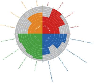
3.1.1.YUTPA ANALYSIS
YUTPA ANALYSIS – TOURIST
The YUTPA framework, acronym for being with You in unity of Time, Place and Action, sheds light on specific presence configurations in which a person performs presence with YOU, in the NOW, being HERE, with a specific potential to DO certain things. (Nevejan 2014)
In this analysis, we understand the value of design in relation to presence of a person in terms of experience that defines an individual’s wellbeing and survival. From the point of view of public spaces, we define the YUTPA analysis for two kinds of users of public space, i.e the tourists who are temporary but important, and the Texelaars, the local community who define what implications are allowed to make changes to their “home land”.
The following analysis is subjective indicators and not objective calculated outcomes for facilitating conversation about a specific presence of design
We use this analysis to define the experiences we think are important or not priority for the users. This furthers us to emerge into a conceptual framework where we can tackle infrastructures relating to social, economic and technical aspects of sustainability in public spaces.
Relation: the tourists visiting Texel have one role: as tourists. Their role as a doctor or a coast guard in other place is not so relevant as their reputation in this place. In public places of Texel, on an average, the tourists will be well behaved and display a kindness which we perceive as people with good reputation. In essence, this defined the activities they can perform, and hence a high engagement. This also defines what level of sustainable intervention needs to be designed. Since the people have a high rep, they will be more aware and concerned about avoiding unsustainable solutions, for example, dumping waste bottles on the streets, as observed in touristic destinations in mainland. However, they do not truly connect to the importance of for example the historic sights. Hence, they do not exactly share the same meaning with the Texelaars; hence the communion is low.
Time: as people in public spaces, it is relevant to have a large amount of duration of engagement. As tourists on a holiday, the time they spend in activities is more important and adds value to their experience. They also want some level of privacy; hence, they are not outdoor 24x7. However, it is important to make some special moments that are of significance and that bring them again to the island. Their engagement with public spaces has neither a need to be synchronized nor integrated with the daily activities of the local people.
Place: the experience for a tourist has a direct relation the place. What they feel about being there, the quality of activities and the time spend on them, how it makes them feel about themselves is all-relevant for a public space. This defines the quality of the experience, and well being they observe on the island. The emotion attached to how it makes them feel or what they can do in the place is the key factors of the experience. Hence, the situated agency is important but the body sense plays a key role, as it is the connecting factor to the emotional space and situated agency. Of course, what they do/ products they require have a direct relation to the environmental impact.
Action: the quality of deeds relating to a temporary individual in a public space relates to activities that he or she performs for leisure. These are different from activities they would need to do to synchronize performance, and also less relevant for their experience as a tourist. Also as a tourist their experience of wellbeing is far from a negotiation they would need to perform on a regular basis. However, when we involve some amount of tourist experience with the locals, we get a higher level of give and take relationship, where each party can learn from the other.
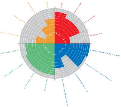
YUTPA ANALYSIS – TEXELAARS
Relation: the Texelaars vary in age groups. The relation to one another, in respect to public space is mainly familial, friendly and in rare extended cases, professional. It is thus a place where family friends and sometimes colleagues meet for a hang out or a good time together. The role they play, as a family person or a friend, defines their actions, and hence role is given high importance. Also, since Texelaars are the primary users of the public place in summer and winter, their engagement to the space is very important. This also leads to a very high communion.
Time: Different people have a different preference to use the public spaces, at their convenient time. In essence, it is available for use during its opening hours for all the time that it is open. Hence, it is as high as possible. The rhythm of the users is to some extent affected by the rhythm of the service providers, for example, of the bakery or the library. It also sometimes is instrumental in making moments to signify that will add value to the Texelaars’ experience.
Place: The Texelaars are the ones who will use this space in summer and winter. For them, this public space should not lose its meaning with the seasonal changes in weather conditions. Hence, it is important to include them in every stage of designing. The locals should have some awareness about how they feel about their bodies, which defines, for example, how they dress. But it is irrelevant sometimes if they are just for a regular outing. The emotional space will also be high as their local monuments would remind them of their history and the natural systems will keep them integrated with the ecology. In this sense, they will have an environmental impact depending on the activities they do in the public spaces.
Action: it is important for the Texelaars that they have a fair trade and they get back what they invest in, in terms of both cost and deeds. This necessarily means that these have to be in tune for Texelaars with each other; for example, the installation of a sustainable option should not destroy the quality of someone else’s life. In this sense, it does not matter what sustainable options the neighbor intends to install, hence the quality of deeds does not have so much relevance as the reciprocity or negotiation.
To conclude, we analyze two types of actors: the tourists and the Texelaars. We observe that all the four actions of action, relation, time and place are very important to Texelaars in terms of public space. However, for the tourists, memories play an important role, hence the time they spend and the place they are in, these factors have primary importance. Since public space is a common ground for the locals and the tourists, it is important that there is some interaction of tourists and locals, so they spread their local knowledge and goods to the mainland, but it is also important to preserve the local culture and not be drowned by the globalization that is generated by the influx of the tourists. A sustainable solution should find a good balance between these two aspects.
3.2.Landscape
The aim is that each village show their own identity through landscape. Regarding that it is proposed to recover the old nature landscape. In fact, Texel is famed for its large numbers of orchids and some unusual plants, typical of the Wadden Islands because they prefer the salt marshes. The area of the Wadden is a nursery and provides shelter and an inexhaustible source of food for birds, fish and marine mammals. Therefore, old plants and landscape are being reincorporated to the island and new and pleasant walking paths and cycle rides are introduced to the public space within the island for locals and tourists. (Texel.net, 2014)
3.3.Technologies
The future of public space as our proposal would be multiple use of the same space available. The strategy is to use “Circular Flow Land Use Management” sustainable criteria based on “avoid”, “recycle” and “compensate”. It is also propose to use the concept of “placemaking” to further explore possibilities of shaping the culture of sustainability awareness.
While environmentalism has challenged human impact on our planet, it is not the planet that is threatened but humanity’s ability to live viably here. Placemaking is the communal capacity, for people to thrive with each other and our natural world, which is dedicated to encouraging and empowering people to take ownership over and contribute to the world beyond their private property and work together to improve them. It is the common sense process through which the human places we most value are created and sustained. (PPS, placemaking)
In essence, the future public spaces will be not one space for one function but rather one space for a multitude of changing functions. These spaces are then defined by what kinds of functions the tourists and mainly the locals would want to ensure that these spaces are most active and efficiently used.
“Circular Flow Land Use Management” and “Placemaking” criteria promote the use of the current technologies instead of waiting for the development of one, in order to ensure fast and instant applications. This involved a multitude of possible technological interventions. Smart lighting and solar power could be possible options of smart technologies in application. However, simple techniques such as glow paints instead of bright light, especially at the ecological fringe will be effective. The technologies will address harmony of ecological, social and economic aspects.
Places for initiatives for social awareness will be a key goal for use of these technologies.
This will take into place by two steps: first educating the people of the interventions needed, next inviting for realistic design proposals, and lastly, taking a public vote on the solutions presented. The approach of this development system will be the use of back-casting method, meaning that the desired future will be worked out backwards by identifying policies and programs and then connect future to present
These approaches combine
1. The involvement of a broad range of stakeholders and actors from different societal groups including government, companies, public interest groups, and knowledge bodies, not only when defining the problem but also when searching for solutions and developing shared visions.
2. Incorporating not only the environmental component of sustainability, but also its economic and social components.
3. Taking into account the demand side and the supply chain as well as related production and consumption systems. (adapted from J.Quist, 2013)
The agenda includes channelizing human, social, economic, infrastructure and cultural capital into the generation of place capital (adapted from The Benefits of place)
3.4.Rules and regulations
'Nature for people, people for nature'.
Currently, more and more initiatives between public and private parties are coming off the ground and benefiting local economies. That is why the Dutch Government set out a plan to realize a national ecological network made up of large, interlinked nature areas. The aim is the network comprises 750,000 hectares, or roughly 18% of the Netherlands’ area by 2018. In fact, the national ecological network will form the core of Dutch nature. Hence, it will enable the sustainable preservation of both common and rare plant and animal species in the Netherlands.
In order to develop a sustainable island and regarding public space some aspects have to be taken in account for the development of future policies. Nowadays, public space is a place for social and economic exchange, such as, street markets, car boot sales and community centers, all of which need consideration in local public space strategies.
First, future policies and proposals for public space should be based on a better understanding of people’s use of existing spaces and places, particularly street markets and traditional high streets. Thus, integrating economic, social and cultural aspects.
It is important to develop inclusive policies that take in account local attachments to existing places and activities. Besides, it is important to generate playful spaces. Children still need opportunities for outdoor play in neighborhood spaces, not just fixed equipment playgrounds, in order to participate in communal games, which in turn create a sense of belonging and attachment to local places. Some studies suggest that successful public spaces should build on the large degree of self-regulation of public behavior that already exists. What is more, better coordination is required to address the multiple concerns of accomplishing design, efficient management and maintenance and social cohesion and inclusion.
On the other hand, regarding public space management in Texel, it is important to take in account some aspects for example wildlife management. Therefore, it is propose to include within the policy of the place a Geocaching management, where people can integrate education, recreation, and nature, but some regulations are needed in order not to affect any wild ecosystem. (Worpole, 2007) (SamenwerkingsverbandNationaleParken, 2014) (Ecomare, 2014)
3.5.Interrelations
As it was mentioned before the aim is to improve public space within the island through showing and promoting the identity of Texel and its seven villages, so people are going to feel attached to it. What is more, as it was mentioned before, there are two main important actors regarding public space within the island, local people and tourists. Hence, it is proposed to promote a new approach of public space by combining education, culture and nature. The strategy is to identify some identity aspects within each village and connect them through interactive connections that combine education, culture and nature.
Bibliography:
PPS, placemaking, (http://www.pps.org/reference/placemaking-as-a-new-environmentalism/)
The benefits of place, http://www.pps.org/reference/place-capital-the-shared-wealth-that-drives-thriving-communities/
J.Quist, 2013, Backcasting and Scenarios for Sustainable Technological Development, Delft university of Technology.
Worpole, K. &. (2007, 04 23). The Social Value of Public Space . Retrieved 12 5, 2014, from Joseph Rowntree Foundation: http://www.jrf.org.uk/publications/social-value-public-spaces
Ecomare. (2014). Dutch Nature policy. Retrieved 12 5, 2014, from Ecomare: http://www.ecomare.nl/en/encyclopedia/man-and-the-environment/nature-management/nature-policy/
SamenwerkingsverbandNationaleParken. (2014). Dutch Nature Policy. Retrieved 12 5, 2014, from Samenwerkingsverband Nationale Parken: http://www.nationaalpark.nl/documents/nationale-parken/nederlands-natuurbeleid.xml?lang=en
Texel.net. (2014). Nature Reserve. Retrieved 12 12, 2014, from Texel: http://www.texel.net/en/about-texel/nature/nature-reserve/
Public Space- Comparision

4. Comparison
4.1. Actors
4.2. Landscape
4.3. Technologies
4.4. Rules & Regulations
4.5. Conclusion
4. Comparison
4.1. Actors
4.2. Landscape
4.3. Technologies
4.4. Rules & Regulations
4.5. Conclusion
4.1 Actors
Regarding the actors the future sub-system wants to also attract the age group less than 45 years of age (which is the current age group- 45 years and above). This is because we want to encourage the younger generation to be influenced and inspired by the activities and initiatives on the island. what’s more, they have a place for a relaxed holiday and an added benefit of being a part of sustainable initiatives. This also relates to trends within the actor’s mind set.
Unemployment: it is expected that in future the unemployment will be less due to influx of tourist. However, the winter condition, where the unemployment is low, is still unpredictable for a future sub-system scenario.
Although no problem definitions were identified in the current activities, several proposals for the current system will be improved from specific tourist activities, such as visiting the beaches, walking and hiking, shopping, visiting village, dining, enjoying nature, cycling, among others.
In order to provide comfortable environment for the tourists it is important to take into account activities (especially for kids), safe accommodation, beaches and nature, interaction places (Public), thermal and social comfort.
4.1.1 YUTPA graph
Tourist Analysis
Fig4.1.1a: YUTPA graphs: Current system and future system respectively (for tourists)
Relation:
In the future design, the role of tourist decreases in the sub-system and the reputation increases. This is because we want to attract good reputation amongst the tourists. However, the higher priority lies in engaging the tourists in the sub-system. Communion has little effect also in the design proposal.
Time:
In future, we want to reduce the time of tourist. The reason is simple. We do not want an overload of tourist. By keeping the duration of engagement same and maintaining the integration of rhythm, we want to make a larger impact on sustainability awareness. Significant moments as a tourist or synchronization of performance, with respect to public space, will have less impact for tourism in future proposal design
Place:
For tourism, the future sub system in terms of tourist in place is almost same as the current, with the exception of reduction in environmental impact of the tourist. This is only possible to limited extent and we are more realistic regarding this rather than being ambitious.
Action:
The future design proposes to increase the negotiation and reciprocity between Texelaars and tourists. The rest of the actions performed by tourists will have little impact on the sub-system.
Texelaars Analysis
Fig4.1.1 b: YUTPA graphs: Current system and future system respectively (for Texelaar)
Relation:
We propose to reduce the role of Texelaars in the public space, but considering these are located in villages where everyone knows everyone, the role is rather difficult to take away. We also propose to increase the engagement while reducing the communion, because this will ensure a wider variety of ideas and possibilities of innovations.
Time:
The future sub-system proposes to increase all the aspects of time except integrating rhythm. Infact, proposal is to reduce this in order to keep the space active and not too populated during different times of the day. This also ensures vibrancy and allows the (function) “re-use” aspect of the public spaces.
Place:
The future sub-system proposes to increase the situated energy and environmental impact of Texelaars. However, it must be noted that the environmental impact considered here is a positive one, and hence higher.
Action:
Actions performed by Texelaars are very important. This builds trust and a feeling of belonging. For tourist, this could mean a good relation, happy memory, innovative thoughts and willingness to spread the word. Hence, in the future sub-system, we propose a high negotiation, reciprocity and tuning compared to the current situation.
4.2 Landscape
The landscape in the future subsystem will relate more to the landscape that was before the excessive intervention of human, more nature, birds and environment will be taken into incorporation. currently, some villages are already developing on these lines. our proposal will be to reduce the public spaces and incorporate more natural habitat in those areas. also, if new public spaces are needed in recent years, the landscape and environment will be compensated in different ways, thus more nature focused approach compared to the current system.
4.3 Technologies
The current and projected development in terms of trends and technologies has a fundamental difference: from the current economic prospects of these spaces and interventions, we will focus more into ecological aspects. Where initially the nature was treated as a separate object, we will include it in the future sustainable developments but in a way to protect it. Also, from enlightening the users of the space, the future system will engage citizens, this will make them more involved into sustainable interventions as they will treat them as “their own neighborhoods” defined by “ their own actions” instead of somebody else’s (generally the government’s) responsibility. This will give people the power to innovation in incorporating the technologies and the public space provides a platform for stakeholders to help in initiating programs if necessary.
In summary, the figure below describes the difference between the current systems and the future systems.
4.4 Rules and regulations
Regarding rules and regulation for public space, currently, local and international governments and policies have included many regulations that attempt to improve nature management, however it is important to include some inclusive regulations within these existing policies that allow protecting nature and at the same time generating recreation, education and income for the locality, thus producing a social and economic exchange. What is more, government should include some regulations about how to be a good visitant (tourist) and how to be a good host (local). Therefore, the proposed goals can be achieved successfully. Furthermore, it is important to take into account the customs and the traditions of the locals while developing any policy, thereby enhancing the sense of belonging and attachment to local places, while, at the same time, creating social cohesion and inclusion.
4.5 Conclusion
The implication of the concept: reduce- reuse- recycle needs more than just a planning it. It should also take into account the government initiatives that can make this possible, the tourists which are the economy driving factor and most importantly the locals who will use this public space as they define whether or not a system will be implemented at the first place. By “placemaking” people should be involved in the development of solution. This ensures a feeling of making the neighbourhood their own, and strengthens the community feeling of within each individual. This will ensure the transition between the current and the future sub-system. With a good policy planning from the government, the people will be motivated in taking steps towards sustainability. As mentioned in the chapter 3.4, while planning a good policy, the government should think in terms of back-casting while never ignoring identity of place by rather improving it.
However, we should keep in mind that each of the seven villages in Texel has a unique identity. Thus a general proposal will not be ideal solution for the different villages. Hence, it is important to identify the different identities of each village and encourage the local pride into taking steps towards improvement of environment by giving impetus to the identity of the village. Thus a plan must be charted with the community which will work on 3 levels- ecological (sustainability), social (identity), and economic (tourist, circular flow public space and activities). These will be further addressed in the upcoming chapters.
Tourists are the focus of distribution and awareness of the sustainability measures on the island’s public spaces, but it should not be forgotten that the locals play an important role in gaining the trust of the tourists at the first place. We see from YUTPA graphs that a high reputation of and actions between the tourists and Texelaars will ensure a greater level of trust even if the time spent between the two entities is less.
PUBLIC SPACE - Proposal
5. Proposal
5. Proposal
The main propose of this project s to promote a new way of public space within the island by fostering the identity of Texel and its seven villages and promoting the interchange of products and knowledge. The idea is to promote the interchange of knowledge and products within specific nodes through iconic elements that promote the identity of the island. As a consequence, it is expected that people are going to feel attached to the island, and a sustainable tourism is going to be promoted at the same time. Hence, it is proposed to promote a new approach of public space by combining education, culture and nature. As it was mentioned before, the strategy is to identify some identity and/or iconic aspects within each village and connect them through interactive connections that combine education, culture and nature. In summary, our ambition for Texel is to become a sustainable pioneer for the Netherlands and surrounding Wadden Islands by improving the knowledge of the tourist about the sustainable solutions of Texel, its culture and nature. Besides, as it was stated before, the plan is to incorporate “Circular Flow Land Use Management” and “Placemaking” criteria to promote the use of the current spaces and technologies to ensure a fast and instant application, regarding that pubic space represents either a meeting point, market place or traffic place.
What is more, for the development of a sustainable public space within Texel, it is planned to involve the community in the development of new projects. The idea is to organize meetings with the community to exchange ideas and find solutions within Texelaars, regarding a sustainable approach.
As a case study, it is planned to analyse De Koog, due to the fact that it has a lot of potential to develop this idea of a sustainable public space, that promotes identity and the interchange of knowledge and products within the inhabitants and the tourists.
Next is mentioned some iconic and identity aspects of each village.
- Oosterend: The fisherman village. In fact, it's the hometown of most fishermen on Texel and it is the second largest village on the island. What is more, Oosterend is built around Saint Martin's Church a church (Maartenskerk) that is one of the oldest churches in the Netherlands.
- Oudeschild: The fishing harbour. It is the home harbour of the Texel fishing fleet.
- De Hoorn: Piloting ship and Flower bulbs.
- Den Burg: Esperanto. It is the largest city of Texel
- De Waal: Sommeltjespop. Sommeltjes are kinds of trolls that appear in folk stories on Texel. It is the smallest village.
- De Koog: Fishing village. It represents the centre of tourism on the island
- De Cocksdorp: The lighthouse. It is the youngest village.
(Texel.net, 2014) (Wikipedia, Wikipedia, 2013)
Bibliography:
Texel.net. (2014). Villages. Retrieved 12 12, 2014, from Texel: http://www.texel.net/en/about-texel/villages/
Wikipedia (2014). Texel. Retrieved 12 12, 2014, from Texel: http://en.wikipedia.org/wiki/Texel#Geography
PUBLIC SPACE - Evaluation
6. Evaluation
Public space: in relation to other sub-systems:
Our proposal is to generate a platform of awareness will reach out to many sub-systems in a positive way. Our proposal of reduce- reuse – compensate, on the other hand, generates also more people on less square meters compared to current system. This may have positive and negative impacts that we have to be aware of:
Leisure and Knowledge and Public Space:
This is the one of the most important links to our sub-system. The group proposes four plan of actions, which are: 1. Creation of the “sustainable route”, 2. Active role of schools, 3. Make all businesses sustainable, and 4. Creation of the “Center of Innovation”
For us, creation of innovation is one of the most important goals to achieve, as we want to inspire more tourists and locals by having a constant display and interaction between the tourists and the Texelaars. We have to be aware that we do not want to influence the sub-system’s goals in a negative way but only provide information and inspiration for their path.
Materials and Waste and Public Space:
Although it is hard to promote Bio-cycle, which is primary goal of the sub-system proposal, we have to be careful about the proposal that we make when it comes to materials used and the waste produced. It would be unwise to promote sustainability but use unsustainable materials or attract activities that would generate large amount of waste that we must process.
Sustainable Mobility and Public Space:
Although this affects less directly to public spaces, we have to remember that the public spaces are a sort of “focal points” for the tourists and especially for the Texelaars. Thus, in keeping with the sub-system’s policy of carpooling, green wheel style rentals and bike systems, the public spaces can provide a sufficient number of the travel desks that can provide these systems. However, with our policy of reduce the need for public spaces, this also reduces public transport options and could impose an undesired impact on the environment.
Texel as a host and Public Space:
This is an important aspect that will generate trust of tourist by improving the relationship among tourists and Texelaars. By our proposal of Avoid-Reuse- Compensate, there might be more tourists on fewer public spaces then current scenario. Our sub-system has to be careful about not overloading tourist with sustainable information, but making them curious enough for them to ask the Texelaars for information. This has to be subtle but strong memory or influence, whilst always keeping in mind the primary goal as a host. Also, we have to understand the capacity of a host and not overload this by excessive tourism. This means that the primary function of public space should not be taken over by the knowledge platform.
Water-cycle and Public Space
There might be a potential danger to excessive use of water due to the high amount of tourists. The goal of the water-cycle sub system is to generate awareness within local people by giving a voice to start-ups interested in water management related services. This goal is again, in keeping with our main goal of an awareness platform.
PUBLIC SPACE - Texel Week
7. Texel Week
7.1 Current Situation
7.2 Future System
7.3 Transition
7.4 Summary
7.1 Current Situation
As it has been mentioned within the previews chapters, Public Space is defined as a meeting place, a market place and/or traffic place (Gehl, 2003). In fact, in order to analyze and categorize a public space it is important to consider the 3P factor, which analyze the interaction between People, Planet and Profit, which should be in balance.
During the last months, it has been a common concern to understand Texel and Texelaars interactions. For instance, what is peculiar about Texel is that a lot of tourists visit the island during summertime, and during wintertime the island is almost completely empty of tourists. What is more, tourists prefer attractive public spaces where many activities are located and centralized, such as leisure, shopping, site viewing, nature, and quietness. Therefore, Den Koog is the main attraction for them because this village centralizes many activities. Nowadays, there are few markets in the island, but according to our interviews, Texelaars prefer to buy their products on the supermarket because is easier; hence, the markets are developed mainly as an attraction for tourists, so just few remain within wintertime. However, every once in a while, Texelaars find interesting products that are going to be sold in the market, so those products catch their attention and they go to the market.
Regarding all these factors and after our previous analyses, the visit of the island and the interviews with the inhabitants, it has been stated that nowadays, public space is mainly adapted to the tourists; hence, Texelaars earn their money from them. Even though, Texelaars are closely related to each other and to the island.
It is important to mention that many tourists come to Texel to visit and enjoy the nature within the island. Although, for the further development of the subsystem only the public space within the villages are going to be considered in this research, the beauty of the nature of Texel should not be ignored. In fact, the surrounding nature of the villages should be emphasized in order to embed the village in the nature of Texel.
7.2 Future System
It is clear that we want to achieve no intervention at natural landscape areas that include beach and dunes. We propose to preserve these and focus on the built environment and use it more efficiently, keeping in line with ecomare. We propose to use areas where there is infrastructure already existing and enhance the interaction of tourists and Texelaars. The focus is on showing the innovation on the island and sharing the knowledge and the targets groups are both the islanders and the visitors.
The aim for the future system is to use public space a connection node within the other subsystems. This is done with two methods: A First Ever “SUSTAINABLE MARKET” (and events) and “Markers indicating other innovations”
7.2.1Sustainable market:
On speaking to the locals, we realised that the weekly markets are mainly aimed at tourists. The Texelaars prefer to buy their local needs from the shops. However, they do visit these markets when they want to buy something specific from a market, for example when they hear about some special cutlery from olden times. they also confirm that if there was an innovation market every week, they would visit it much more often to check if there was something for them.
“The First Sustainable Market” at Texel once a week will initially begin with a stall at the market selling innovative sustainable produce from Texel. We selected De Koog as a starting point of these markets. Once this idea takes flight and gets more popular among the people, it can be even expanded to other villages. The reason of selecting De Koog is simple, it has a high influx of tourists, and hence, best to make a good first impression, because the foot fall will be high. The church square (where market is located) is a common passing point and the place will definitively make the passerby curious.
To develop this system, the time of the year is going to be very important factor. The market is more oriented towards the tourist during summer-time whereas in wintertime the products on the market are relating more Texelaar and outsiders visiting island for special purpose. The characteristic difference between this market and another market is that, this one will also invite young and not fully mature innovators to come and demonstrate their idea.
The major advantage of this is the fact that no additional infrastructure is required for building it. The tents and market already exists, the living quarter around it also exists, and also the websites where these are informed to tourists. However, a managing committee is required that helps small and medium scale innovators by providing them this platform.
As more and more tourists are getting aware to the innovations and the growth of the new sub-systems, the public spaces should also be extended to annual events which should be organised in squares and public buildings and related innovators (in addition to the general visitor) should be invited to conference/ seminars/ workshops. With these events, also the younger people should be involved and children should be encouraged in workshops to start young with sustainability education. The fundamental difference between the culinary event (which is already in practice) and the proposed event is that innovators are invited and workshops should take place that will make people more involved with the real Texel, below the surface of what they see as a tourist.
X.2.2 Markers for the route.
This solution is aimed at the tourists. The fact that they see the physical markers for the food just eaten from the restaurant will make the visitors curious to follow and find out how it actually looks like. These markers direct to the place where the visitor can find more information and ask questions, maybe even be involved in the process. This builds memories of actions created and will bring them back, to explore the other knowledge centres.
The knowledge centres connect to routes and the markers will give impetus to the routes, thus giving a clear physical presence to the route. It is suggestion that the markers should be of same visual appearance and this should be designed in coordination with the community, as they know best.
The fact that this sub-system is the connecting node to other sub-systems essentially means that the Connecting “node” or Public space is dependent on how well are the other sub-systems: how many people want to visit the other subsystems. Furthermore, it is proposed to use public space not just like a connection point, but a place that supports and promotes the other subsystems.
In fact, public space subsystem is totally dependent on the development of the other subsystems, due to the fact that it represents a node that connects them. The strategy is to highlight the connections or routes between the subsystems.
7.3 Transition:
As stereotypical engineers, we first proposed designs for the need for trees and regeneration of nature, allowing birds and fish to live in harmony with the humans, to make this place more sustainable. On our visit, we realised that this will not work, because 1.these initiatives are already being taken and 2. Most of the land does have ecology and are the main attraction points of the tourists.
We saw that the Texelaars do have innovative sustainable Technologies, but what is missing is communication. As tourists, we would almost never realise that these innovations exist. So, by tackling the “disconnect” and providing platform for these interventions, we can bridge this communication gap. This also requires support from the locals to make it successful.
When you are in a square or commonly travelled road, by visual markers it will be easier to be directed to the knowledge centres. The public markets that will further extend to events will involve the visitors in the knowledge at land, and this will attract a large number of younger people to participate in the activities, because they learn something new and what’s more- they participate in them!
These squares and markets will, therefore, promote the knowledge based on Texel. The public space will thereby provide a physical common ground for the sharing of this knowledge and showing up the innovations. We observe that Texelaars are proud to be a part of the island. to be a part of an innovative island and be known by the outsiders as the innovative people reinitiates the sense of pride and public space proposals like these will help in providing a physical platform and a visual voice there. With these strategies, it is expected that the role of visitors on the island will change from being mere tourist to more aware individuals. The market would take time for large scale recognition. However as a beginning point, we can already start using the innovations that are developed on the island by markers and events, and even starting the pilot “Sustainable Market” project that can showcase the innovations from various researchers and events.
As it has been mentioned before, Texelaars are closely related to each other and to the island, and the subsystem proposes to promote it. Therefore, the meeting places should reflect the identity of Texel. The public spaces and events should highlight the Texel beyond the Touristic vision and enhance the current events in innovation direction, something that the Texelaars are extremely good at
7.4 Summary
The aim is to improve public space within the island through showing and promoting the identity of Texel and its villages, so people will have a feeling of attachment to the Texel land. Moreover, we realized that the Public Space as a subsystem completely depends on the other subsystems: the success of those systems is going to allow the success of the “Sustainable Market”, that will allow the interchange of knowledge and products among tourists and inhabitants.by using designs from the locals, we can place the markers at public splaces like squares and traffic junctions.
The strategy is to promote the identity of the island by integrating the knowledge centres relating to the other sub-systems, and connect them through connections that promote their essence.
It is highly suggested that in order to achieve the goal of a sustainable subsystem and/or island, environmentally friendly technologies and strategies need to be supported by the integration of cultural, social, educational and environmental policies that create the ethical and intellectual knowledge, skills, attitudes and behaviours of citizens.